Rare Books
Map of the Isthmus of Panama representing the line of the Panama Rail Road as constructed by George M. Totten, Chief Engineer &c reduced and compiled from the original surveys / by Thos. Harrison, Crown Surveyor

You might also be interested in
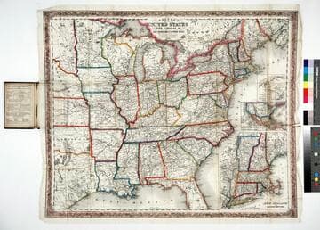
Colton's map of the United States, the Canadas &c showing the rail roads, canals & stage roads with distances from place to place
Rare Books
Kirkpatrick Catalogue entry: "2463 Colton, J. H., publisher. Colton's map of the United States, the Canadas &c. showing the rail roads, canals, & stage roads ... New York, J. H. Colton, 1860. 1 sheet. [see p.]."Alternate title from cover. Submaps: Map of New England and Eastern New York; Map of the United States & Central America; The Isthmus of Panama showing the Routes of Travel between Aspinwall & Panama. . Prime meridian: GM, Washington. Relief: hachures. Graphic Scale: Miles. Projection: Polyconic. Printing Process: Lithography. Other Features: Sub-maps. Verso Text: MS note: R.B. 11486, i Stamp: Kensington Public Libraries.
623637
Image not available
Map and profile of the Panama Rail Road and adjacent country exhibiting the Rio Chagres Mule Roads from Gorgona & Cruces to Panama and the ports of Limon or Navy Bay on the Atlantic and the Bay of Panama on the Pacific being the Termini of the road together with the line of a Rail Road approximately laid down by Co. George W. Hughes from Gorgona to Panama : this Rail Road was commenced in the year 1850 and the last rail was laid 27th January, 1855: the whole has been constructed under the direction of George M. Totten, Chief Engineer and James L. Baldwin, Assistant Engineer, and this map compiled in June and July 1855, from the various surveys made during the above period / by Thomas Harrison, Crown Surveyor, Jamaica
Rare Books
Publisher derived from Phillips, A list of maps of America, p 657. Date derived from notations of later surveys on map. Extremely long (14+ ft.) map with great detail. Prime meridian: GM. Relief: hachures. Graphic Scale: Miles, feet. Projection: Plane. Printing Process: Lithography. Verso Text: MS note: 353038.
353038
Image not available
Map of part of Slocan Mining Camp, West Kootenay, B.C. / Compiled by W.S. Drewry, Provincial Land Surveyor
Rare Books
"Kaslo & Nelson" "April 1897" "Entered according to Act of Parliament of Canada, in the year 1897 by W. S. Drewry, at the Department of Agriculture." "'The Province' Victoria & Vancouver, B.C." "T. Bamford Draughtsman, Victoria, B.C." Submap: Key [Area] Map. MS note: 344043. Prime meridian: GM. Relief: no. Graphic Scale: Feet. Projection: Plane. Printing Process: Lithography.
344043

Survey of Lake Champlain, including Lake George, Crown Point and St. John. Surveyed by Order of His Excellency Major General Sr. Jeffery Amherst, Knight of the most Honble. Order of the Bath, Commander in Chief of His Majesty's Forces in North America, (now Lord Amherst) by William Brassier, Draughtsman, 1762
Visual Materials
Kashnor notes, "A rare map, issued specially for British Troops serving in the Revolutionary War." Sub map of Lake George Surveyed in 1756 by Capt. Jackson. Shows naval action at Valcour Island and Buttonmold Bay in Oct. 1776. Sub map of Lake George, Surveyed in 1756. by Capt. Jackson.. Relief: hachures. Graphic Scale: Miles, British. Projection: Plane. Watermark: Crowned fleur-di-lis V I. Printing Process: Copper engraving. Other Features: Sub-maps. Verso Text: 18 MS note: 112.
093:112 M
Image not available
Geological map of the Mother Lode Belt in El Dorado & Amador Counties, California : compiled by Henry Lahiff Civil Engineer U.S. Deputy Mineral Surveyor
Visual Materials
No old shelf mark. There are two copies of this map in the same folder. One copy notes on verso there were originally three copies. Identical except for the verso note. Description of mining techniques. Prime meridian: GM. Relief: no. Graphic Scale: Miles. Projection: Cylindrical. Printing Process: Lithography. Verso Text: MS note: California. "The Mother Lode Belt." El Dorado and Amador Counties Geological Map (3 copies).
ephMPCALIF0192
Image not available
Territory of the United States from the Mississippi River to the Pacific Ocean : originally prepared to accompany the reports of the explorations for a Pacific railroad route ; made in accordance with the 10th & 11th sections of the Army Appropriation Act of March 3rd 1853 ; compiled from authorized explorations and other reliable data / by Lieut. G. K. Warren, Top'l. Eng'rs in the Office of Pacific R.R. Surveys War Dept. under the direction of Bv't. Major W.H. Emory, Top'l Eng'rs in 1854 ; Capt. A.A. Humphreys, Top'l Eng'rs in 1854-1858 ; Recompiled and redrawn under the direction of Chief of Corps of Engineers / by Edward Freyhold 1865-66-67-68
Rare Books
At head of title: "Headquarters Corps of Engineers, War Department." For another copy see RB 127677; for the top half of the original 1857 map on which this is based, see RB 49791; for a reduced reproduction of the original 1857 map, see RB 342277. Cover has sticker from Henry R. Wagner's library. Submap: Territory of Alaska ceded by Russia to the United States 1868. Authority Table. Prime meridian: GM. Relief: hachures. Graphic Scale: Miles. Projection: Polyconic. Printing Process: Lithography. Verso Text: MS notes: 43236 Maps -US U. S. Eng Dept. ... Terr. of the U.S. N.Y. 1868.
43236