Visual Materials
An accurate map of New York in North America, from a late survey
You might also be interested in
Image not available
An Accurate Map of New York in North America, from a late survey
Rare Books
In the folder are leaves from Universal Magazine of August 1780. This map apparently published in conjunction with an article on New York. MS note: 1780 Mat sticker: 951. Prime meridian: London. Relief: pictorial. Projection: Cylindrical. Watermark: Two circular seals. Printing Process: Copper engraving. Verso Text: MS notes: 1780 150062.
150062

An accurate map of New Hampshire in New England, from a late survey
Visual Materials
Kashnor dates as ca. 1776. Maine is shown as part of New Hampshire. RLIN record gives place of publication, date, and appeared in information as Universal magazine of knowledge and pleasure, March, 1781. MS note: 112 (on backing). Prime meridian: London. Relief: pictorial. Projection: Cylindrical. Watermark: Seal. Printing Process: Copper engraving. References: McCorkle N781.1.
105:112 S

A new and accurate map of the present seat of war in North America, from a late survey
Visual Materials
Kashnor notes, "A scarce map, issued during the early part of the Revolution." Kashnor dates c.1776. RLIN record places publication in London and appearance in Universal Magazine. MS note: 107 (on backing). Prime meridian: Ferro. Relief: pictorial. Graphic Scale: Miles. Projection: Cylindrical. Watermark: Two seals. Printing Process: Copper engraving.
105:107 S

A new and accurate map of New Jersey, from the best authorities
Visual Materials
RLIN reference gives author, place of production, and notes this map is from Universal Magazine, v. 66, June 1780. Kashnor dates as circa 1780. MS note: 113 (on backing). Prime meridian: London. Relief: pictorial. Projection: Mercator. Watermark: Seal. Printing Process: Copper engraving.
105:113 S
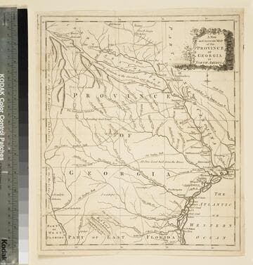
A new and accurate map of the province of Georgia in North America
Visual Materials
Kashnor notes," An old map published about 1775, shewing the roads and Indian paths." Kashnor dates c.1775. Duplicate map to 093:094S, 093:391. RLIN record notes date as [1779?] and place of publication as [London?] and as appearing in The Universal Magazine of 1779. MS note: 103 (on backing). Prime meridian: [Ferro]. Relief: pictorial. Projection: Cylindrical. Watermark: Crowned circular seal. Printing Process: Copper engraving.
105:103 S
Image not available
An Accurate Map of North America
Rare Books
Two sub maps: A Particular Map of Baffin and Hudson's Bay; The Passage by Land to California Discover'd by Father Eusebius Francis Kino.. Voluminous text regarding sections of the treaty and other explanatory details. RLIN record gives appeared in information. Note this is a later printing of the map 093:146 in the Museum Bookstore collection, and is designated 093:147. "Describing and distinguishing the British and Spanish Dominions on this great Continent; according to the Definitive Treaty Concluded at Paris 10th Feby. 1763. Also all the West India Islands belonging to and possessed by the several European Princes and States." "The whole laid down according to the latest and Most authentick Improvements, by Emanuel Bowen, Geogr. to His Majesty And John Gibson Engraver." Elaborate cartouches, on title and scale. Two sub maps. Prime meridian: London, Ferro. Relief: pictorial. Graphic Scale: Miles, leagues. Projection: Pseudocylindrical. Watermark: Crowned fluer-di-lis. Printing Process: Copper engraving. Other Features: Cartouche Sub-maps. Verso Text: MS notes: 149502 147 cat 93 2 sheets [printed] 5 6.
149502