Visual Materials
Map of the northern part of the State of Maine and of the adjacent British provinces : shewing the portion of that state to which Great Britain lays claim Reduced from the official map A with corrections from the latest surveys / by S.L. Dashiell
You might also be interested in
Image not available
Map of the northern part of the State of Maine and of the adjacent British provinces : shewing the portion of that state to which Great Britain lays claim reduced from the official Map A with corrections from the latest surveys / by S.L. Dashiell
Visual Materials
No old shelf mark. Hand colored to indicate disputed boundary. For other copies of this map, see RB 65972 and ephMPME0003. Notes with map: Maine, 1830. Phillips 384. Prime meridian: GM. Relief: hachures. Graphic Scale: Miles. Projection: Cylindrical. Printing Process: Copper engraving.
ephMPME0001
Image not available
Map of the northern part of the State of Maine and of the adjacent British provinces : shewing the portion of that state to which Great Britain lays claim reduced from the official map A with corrections from the latest surveys / by S.L. Dashiell
Rare Books
MS note: X65972. Shows land grants in upper Maine. For other versions of this map, see HEH ephMPME0001 and ephMPME0003. Prime meridian: GM. Relief: hachures. Graphic Scale: Miles. Projection: Cylindrical. Printing Process: Copper engraving. Verso Text: MS note: u.sx/ L.72.
65972
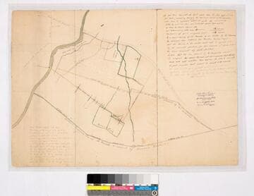
Map of Rancho Paso de Bartolo
Manuscripts
Road from Los Angeles, Road to Santa Ana, southern boundary line of Ranchito [as claimed by Bernardo Girado (?)], San Gabriel River on the western boundary. RANCHO PASO De Bartolo. Case No. stamp dated Jan. 29, 1917. Northern boundary of Rancho de los Nietos as claimed by Mr. Carpenter. Extensive notes by Hansen. Alt title supplied by cataloger.
mssSolano SR_Map_0092.01

Map of Rancho Paso de Bartolo
Manuscripts
Road from Los Angeles, Road to Santa Ana, southern boundary line of Ranchito [as claimed by Bernardo Girado (?)], San Gabriel River on the western boundary. Bordered by Rancho Santa Gertrudes. Rancho Paso De Bartolo. Case No. L.r. 77 Stamp Dated Jan. 29, 1917. Northern boundary of Rancho de los Nietos as claimed by Mr. Carpenter. Extensive notes by Hansen. Alt title supplied by cataloger.
mssSolano SR_Map_0092.02A & B
Image not available
The official map of Orange County California and portions of adjoining counties : compiled from official and private surveys
Rare Books
A detailed map of Orange County before massive development. The northwest corner of the colored border section states, "Boundary line of the Irvine Subdivision." The colored bordered section comprises the Irvine Ranch. Prime meridian: GM. Relief: hachures. Graphic Scale: Feet. Projection: Cylindrical. Printing Process: Lithography. Verso Text: MS note: 435187.
436187
Image not available
Official map of south-west portion of San Bernardino County (including San Bernardino and adjacent valleys) California : compiled from latest official maps of U.S. surveys, railroad and irrigation surveys, county records, and other reliable sources, & / drawn by T.D. Beasley
Rare Books
See RB 477787 for a map of the whole of San Bernardino County. Adopted by the Board of Supervisors as the Official Map October 6th, 1891. Submap: Map of California. Prime meridian: GM. Relief: hachures. Graphic Scale: Miles. Projection: Cylindrical. Printing Process: Lithography.
477777