Visual Materials
Extract from a map of the British and French dominions in North America / by Jno. Mitchell
You might also be interested in
Image not available
Extract from a map of the British and French dominions in North America / by Jno. Mitchell
Visual Materials
No old shelf mark. "This map was Undertaken with the Approbation and at the Request of the Lords Commissioners for Trade and Plantations, and is chiefly composed from Draughts, Charts and Actual Surveys of different parts of His Majesties Colonies and Plantations in America; Great Part of which have been lately taken by their Lordship's Orders and transmitted to this Office by the Governors of the said Colonies and others. John Pownall, Secretary." This is a copy of a portion of Pownall's map drawn later by Stone. For a similar map with slight variations, see RB ephMPME0002. Prime meridian: GM or London. Relief: pictorial. Graphic Scale: Miles. Projection: Conic. Printing Process: Copper engraving.
ephMPME0004
Image not available
A Map of the British and French Settlements in North America
Visual Materials
Kashnor notes, "shewing the French encroachment and forts, and with an account of the English claims to the territories in dispute." Kashnor dates as ca. 1756. RLIN record suggests 1750-59. Cartouche includes Lodge's name. Detailed history of various English colonies. MS note: 622 (on backing).. Prime meridian: London. Relief: pictorial. Projection: Mercator. Printing Process: Copper engraving. Other Features: Cartouche. Verso Text: MS notes: 63 G47.
105:662 S
Image not available
A map of the British and French settlements in North America
Visual Materials
Kashnor notes, "Locates all the French forts in the Ohio and Louisiana territories. A scarce map, issued as a supplement to a magazine during the Old French War." Variant of 105:662. RLIN record gives date and appeared in information. Shows separate North and South parts of South Carolina. Submap: Fort Frederick at Crown Point built by the French in 1731. [Lake Champlain]. MS note: 297 (on backing). Prime meridian: London. Relief: no. Projection: Mercator. Watermark: Crowned GR Lion rampant in seal. Printing Process: Copper engraving. Verso Text: MS note: 297 (on backing).
093:297 S
Image not available
Map of the Most Inhabited part of Virginia containing the whole Province of Maryland with part of Pensilvania, New Jersey and North Carolina Drawn by Joseph Fry & Peter Jefferson in 1775
Visual Materials
No old shelf mark. Later reproduction of this famous map. Beneath vignette: "To the Right Honourable George Dunk Earl of Halifax First Lord Commissioner, and to the Rest of the Right Honourable and Honourable Commissioners for Trade and Plantations. This Map is most humbly Inscribed to their Lordships, By their Lordship's Most Obedient and most devoted humble Servt. Thos. Jefferys." The only published mention of the Litho-Photographic Institute in London is in The journal of the Royal Geographic Society of London, volume 38, May 11, 1868, page 190. The publication date is based on this. Vignette: Traders at dock side. Prime meridian: Washington. Relief: pictorial. Projection: Cylindrical. Printing Process: Lithography.
ephMPVA0004

United States of North America, with the British & Spanish Territories according to the Treaty
Visual Materials
Kashnor notes, "Similar to Faden's map of "The British Colonies in North America," with the addition of colored contours indicative of the British, Spanish, French and American frontiers." See 093:544, 093:545 for later copies. Cartouche of Caribbean traders.. Prime meridian: London. Relief: pictorial. Projection: Pseudocylindrical. Watermark: Crowned fluer-di-lis VI. Printing Process: Copper engraving. Other Features: Cartouche. Verso Text: MS notes : 105 148.
105:148 M
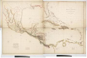
Chart of the West Indies and Spanish Dominions in North America. By A. Arrowsmith 1803
Visual Materials
Kashnor notes, "Amongst other interesting particulars, this map indicates the positions of the canals proposed to be cut by the Spaniards in 1528. The original issue of Arrowsmith's map, valuable for the detail regarding the coast of present-day Texas and the colonies of New Santander." " Jones Smith & Co. sc. Beaufort Build'gs Strand." "To Admiral John Willett Payne, A distinguished Native of the West Indies. Vice Admiral of the Coasts of Devonshire & Cornwall, Treasurer of Greenwich Hospital, Comptroller General of the Household of the Prince, &c., &c., &c. This chart is respectfully Dedicated by his most obedient Serv't A. Arrowsmith." Prime meridian: London. Relief: hachures. Projection: Cylindrical. Printing Process: Copper engraving. Verso Text: MS note: 795.
105:795 M