Visual Materials
New Map of North America from the Latest Authorities

You might also be interested in
Image not available
A New Map of North America from the Latest Discoveries. 1763
Visual Materials
Kashnor notes, "A good map of the far west to the Lake of the Woods, and locating Fort St. Charles and Fort St. Pierre. Shows the old boundaries of Carolina, Virginia, and New England reaching beyond the Mississippi." MS note: 524 (on backing). Prime meridian: London. Relief: pictorial. Projection: Mercator. Printing Process: Copper engraving.
105:524 S
Image not available
Chart exhibiting the New Discoveries in the North & South Pacific Ocean, also those on the North-west Coast of America
Visual Materials
Kashnor notes, "Shows a good coastline to the North-West, and locates Port Sir Fran. Drake, Juan de Fuca Strait, Nootka Sound and other discoveries by Cook." Kashnor notes date as ca. 1780. Prime meridian: GM. Relief: no. Graphic Scale: No. Projection: Mercator. Printing Process: Copper engraving.
105:014 M
Image not available
New Map of America, from the latest Observations, revis'd by J. Senex
Visual Materials
Kashnor notes, "A map which shows an unusually accurate knowledge of the North-West Coast at that time. Although California is represented as an Island, there are two groups of islands which are in the locality of Vancouver and Q. Charlotte Islands, and the coastline extends to the Arctic regions, with a place called Desolation in the part now Alaska. In the same locality are represented great forests, and below are two great lakes which, from their position, may probably be the Great and Lesser Slave Lakes." Kashnor notes date as [1719], confirmed by McLaughlin, who also notes New General Atlas, 1721. Cartouche shows natives with feathered headdress and as cannibals.. Prime meridian: London. Relief: pictorial. Graphic Scale: No. Projection: Pseudocylindrical. Printing Process: Copper engraving. Other Features: Cartouche. References: McLaughlin 193; Wagner 520; Tooley 81; Leigthly 155.. Verso Text: MS. note: 45.
093:045 M
Image not available
North America
Visual Materials
Kashnor notes, "Shows the western coast from old California to Alaska and Icy Cape, locating Port Vancouver, San Francisco, Monterey, and other California towns; also shows the Missouri and its tributaries from Lewis' map. Locates all the forts of the company in Hudson Bay territory." Note "Longitude West of Greenwich" is shown on the map, but the 0° longitude line is at 180° and values proceed eastward from that point. Unexplained crosses along coastline from Cape Mendocino northward. Upper right, partial sticker "No. -". Prime meridian: GM. Relief: hachures. Graphic Scale: Miles. Projection: Pseudocylindrical. Printing Process: Copper engraving. Verso Text: MS note: 562.
093:562 M

Chart of North Atlantic Ocean with tracks of the Shipping to West Indies, North America &c
Visual Materials
Kashnor notes, "Shows the coast of North America from Hudson's Straits, locating the states on the seaboard." Shows routes of US ship Insurgent, Route of Nelson in 1805 in addition to trade routes. Also shows nonexistant "New Sea" between Hudson's Bay and Straits. Prime meridian: Ferro. Relief: no. Projection: Mercator. Printing Process: Copper engraving. Verso Text: MS note: 160.
105:160 M
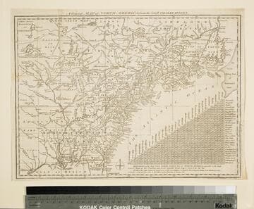
General Map of North America from the Latest Observations
Visual Materials
Kashnor gives date as [1776] RLIN record suggests 1778. Map includes distance chart between 29 American and Canadian cities. Bounds of Hudsons Bay [Co.] shown by Treaty of Utrecht. MS note: 102 (on backing). Prime meridian: London. Relief: pictorial. Projection: Mercator. Printing Process: Copper engraving. Verso Text: MS note: 1776.
105:102 S