Visual Materials
Flintridge : Pasadena's choicest suburb golf course, country club, bridle paths
You might also be interested in
Image not available
Map of the City of Long Beach California : compiled from official records and personal surveys / W.A. Foster, City Engineer
Visual Materials
Old shelf number: eph J5-16(5). Streetcar lines shown in MS red. Verso has cover compliments of Investment Co. MS note H.E.H. on cover. Prime meridian: GM. Relief: no. Graphic Scale: Feet. Projection: Cylindrical. Printing Process: Lithography. Verso Text: MS note Eph J5-16(5). Cover for folded map.
ephMPCALIF0037
Image not available
Lands of the Pasadena Improvement Company, Los Angeles Co., Cal
Visual Materials
Old shelf number: eph J5-17(1). Piedmont Drive is now Altadena Drive. This map shows subdivisions to the west of Lake Avenue and north of Woodbury Road. Prime meridian: GM. Relief: hachures. Graphic Scale: Feet. Projection: Cylindrical. Printing Process: Lithography. Verso Text: MS notes: Eph J5-17(1). P2/4 Part of Pasadena 32a Sticker: No. 24. Pasadena Improvement Co. founded in 1887. Pasadena & Mt. Wilson Railway Co. founded in 1897, sold to Pacific Electric Railway Co. in 1902 (Fickewirth, page 103).
ephMPCALIFT0144
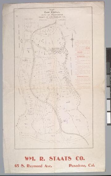
Map of Oak Knoll in the City of Pasadena and the County of Los Angeles, Cal. / surveyed in 1906 by J. O. Marsh C.E
Visual Materials
Old shelf number: eph J5-17(3). An exclusive area even then, the Huntington-Sheraton-Four Seasons- Hotel is shown with it's original name, "The Wentworth." Building restrictions are listed. Prime meridian: GM. Relief: no. Graphic Scale: Feet. Projection: Plane. Printing Process: Lithography. Verso Text: MS note: Eph J5-17(3).
ephMPCALIFT0146
Image not available
Map of the Pickering Land and Water Co's. subdivision of the John M. Thomas Ranch, Los Angeles County, Cal
Visual Materials
Old shelf number: eph J5-12(2). County Road is now Whittier Blvd. For a map of this area after it became incorporated Whittier, see RB ephMPCALIF0035. Prime meridian: GM. Relief: no. Graphic Scale: Feet. Projection: Cylindrical. Printing Process: Lithography. Verso Text: MS note: Eph J5-12(2).
ephMPCALIF0034
Image not available
The Howes Tract Jefferson Street
Visual Materials
Old shelf number: eph J5-8(1). North is at the bottom of this map. Jefferson Blvd at Western Avenue. Vignette: Home photograph. Prime meridian: GM. Relief: no. Graphic Scale: Feet. Projection: Plane. Printing Process: Lithography. Verso Text: Sales information for this tract. MS note: Eph J5-8(1).
ephMPCALIFT0130
Image not available
Map of the Raymond Improvement Co. Tract
Visual Materials
Old shelf number: eph J5-13(1b). MS note: Ynny/ $2.00. Prime meridian: GM. For a map that shows the progress of the land sales, see RB ephMPCALIFT0138. For a map that focuses exclusively on Raymond tract, see RB ephMPCALIFT0012. Relief: no. Graphic Scale: Feet. Projection: Cylindrical. Printing Process: Lithography. Verso Text: MS note: Eph J5-13(1b).
ephMPCALIFT0137