Rare Books
Map of the United States, the British Provinces, Mexico &c showing the routes of the U.S. Mail steam packets to California, and a plan of the gold region
You might also be interested in
Image not available
Map of the United States, the British Provinces, Mexico &c.; showing the routes of the U.S. Mail steam packets to California, and a plan of the gold region
Rare Books
MS note in cover states a manuscript addition to the map, "Shows route pursued by Genl. Kearny on his return from California." The map is preceded by 11 p. of text, with caption: Particulars of routes, distances, fares, etc., to accompany Colton's map of California and the gold region. Collected from official documents. Vignette: Pyramid Lake. Submaps: South America; Gold Region. Prime meridian: GM, Washington. Relief: hachures. Graphic Scale: Miles. Projection: Polyconic. Printing Process: Lithography.
41395
Image not available
Colton's Map of the United States of America, The British Provinces, Mexico and the West Indies, Showing the Country from the Atlantic to the Pacific Ocean
Rare Books
Nebraska extends to Oregon and Washington, Utah to the California border, New Mexico covers Arizona, Minnesota extends west through the Dakotas. Submaps: Central America; West Indies; Newfoundland. Vignettes: Numerous Natives, animals, ships. Prime meridian: GM, Washington. Relief: hachures. Graphic Scale: Miles. Projection: Polyconic. Printing Process: Lithography.
273835
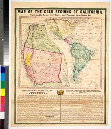
Map of the gold regions of California : showing the routes via Chagres and Panama, Cape Horn, &c
Rare Books
No marks as to maker or publisher, below the map are "Important Instructions" to person planning to use the various routes and another section "Description of California." Because a number of rivers are fairly accurately described the date would appear to be late 1849 or 1850. The map is described and the publisher identified in Carl I. Wheat's Mapping the Transmississippi West, volume 3, page 78, map 609. The map is divided in two sections, one showing an expanded California and Oregon with the Gold Region in yellow; the second showing routes from New York to California and including all of South America. Descriptive tables below map. MS note: 43465. Prime meridian: Washington DC. Relief: hachures. Projection: Pseudocylindrical. Printing Process: Lithography.
43465
Image not available
A New Map of the Gold Region in California
Rare Books
Accompanied by a written description of California. Note that turning point is shown to the west of Mountain Lake (Lake Tahoe) which would have been easier to survey than the actual turning point. "By Charles Drayton Gibbes. From his own and other Recent Surveys & Explorations 1851." "Entered according to Act of Congress in the year 1851 by Sherman & Smith in the Clerk's office of the District Court for the Southern District of New York." Cover title: Accompaniment to Gibbes' New Map of the Gold Region in California. Ms note: 131781. Prime meridian: GM. Relief: hachures. Graphic Scale: Miles. Projection: Polyconic. Printing Process: Lithography.
131781