Rare Books
Map of the United States, the British Provinces, Mexico &c.; showing the routes of the U.S. Mail steam packets to California, and a plan of the gold region
You might also be interested in
Image not available
Map of the United States, the British Provinces, Mexico &c showing the routes of the U.S. Mail steam packets to California, and a plan of the gold region
Rare Books
Printed with sea routes indicated, later overland routes have been added in blue ink. The Gold Region has been hand colored. Submaps: Map of the Gold Region, California; From New York to San Francisco via Cape Horn, 17,000 miles, via Panama 5900 miles. Vignette: Pyramid Lake, Upper California, Discovered by Capt. Fremont 1844, 35 miles long, 1890 feet above the sea. The Pyramid of Rock in the lake rises 600 feet above the surface. MS note: 87485. Prime meridian: GM, Washington. Relief: hachures. Graphic Scale: Miles. Projection: Azimuthal. Printing Process: Lithography. Verso Text: MS note: United States & Mexico.
87485
Image not available
Colton's Map of the United States of America, The British Provinces, Mexico and the West Indies, Showing the Country from the Atlantic to the Pacific Ocean
Rare Books
Nebraska extends to Oregon and Washington, Utah to the California border, New Mexico covers Arizona, Minnesota extends west through the Dakotas. Submaps: Central America; West Indies; Newfoundland. Vignettes: Numerous Natives, animals, ships. Prime meridian: GM, Washington. Relief: hachures. Graphic Scale: Miles. Projection: Polyconic. Printing Process: Lithography.
273835
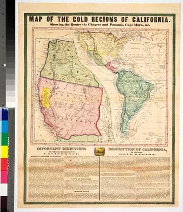
Map of the gold regions of California : showing the routes via Chagres and Panama, Cape Horn, &c
Rare Books
No marks as to maker or publisher, below the map are "Important Instructions" to person planning to use the various routes and another section "Description of California." Because a number of rivers are fairly accurately described the date would appear to be late 1849 or 1850. The map is described and the publisher identified in Carl I. Wheat's Mapping the Transmississippi West, volume 3, page 78, map 609. The map is divided in two sections, one showing an expanded California and Oregon with the Gold Region in yellow; the second showing routes from New York to California and including all of South America. Descriptive tables below map. MS note: 43465. Prime meridian: Washington DC. Relief: hachures. Projection: Pseudocylindrical. Printing Process: Lithography.
43465