Opening Hours
Daily: 10 A.M.–5 P.M.
Closed on Tuesdays
1151 Oxford Road
San Marino, CA 91108
Rare Books
Daily: 10 A.M.–5 P.M.
Closed on Tuesdays
1151 Oxford Road
San Marino, CA 91108

Image not available
Rare Books
Alt. title (MS) from cover. This map shows the routes across the west. This map was a gift to Lieut. Sweeny from a friend, Stephen Dean, who also marked the route Fremont took on his trip to California from Bent's Fort. "Lieut. T. W. Sweeny from his friend Stephen B. Dean." MS notes: Emigrant routes in blue. The red line is Col. Fremont's last route to California from Bent's Fort. Prime meridian: GM. Relief: hachures. Graphic Scale: Miles. Projection: Cylindrical. Printing Process: Lithography.
321276
Image not available
Rare Books
Shows new and old boundaries between Mexico and the United States. Lt. Col. Cooke's Wagon Route through the newly purchased land shown from Foirt Fillomre to San Diego. MS note: 17558. Prime meridian: GM. Relief: hachures. Projection: Pseudocylindrical. Printing Process: Lithography. Verso Text: MS notes: [ca. 1855] m.646 New Mexico 17558.
17558
Image not available
Rare Books
MS note in cover states a manuscript addition to the map, "Shows route pursued by Genl. Kearny on his return from California." The map is preceded by 11 p. of text, with caption: Particulars of routes, distances, fares, etc., to accompany Colton's map of California and the gold region. Collected from official documents. Vignette: Pyramid Lake. Submaps: South America; Gold Region. Prime meridian: GM, Washington. Relief: hachures. Graphic Scale: Miles. Projection: Polyconic. Printing Process: Lithography.
41395
Rare Books
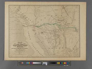
The map shows two probable routes of the Atlantic & Pacific Rail Road via Texas, the reason for the Gadsden Purchase. Someone has added an extension from the Colorado River to San Diego in ink. The mountains which blocked a more northerly route are clearly shown. Note on old folder: Not same as 44064 which is 1858 this map is 1854. Keep and catalog. Hand written notes and rail line to Guaymas. Prime meridian: GM. Relief: hachures. Graphic Scale: Miles. Projection: Polyconic. Printing Process: Lithography.
384988
Image not available
Rare Books
A record of the various proposals for routes through Central America. One note states, "The District of Socomusco formed part of Central America until 1843 when it was taken possession of by Mexico without treaty, and under protest by Guatemala against the occupation." Guatemala is still protesting. "London, Edward Stanford, Charing Cross. 1856." Elevations of 5 different routes shown. BM Maps, 2:224. Phillips, P.L. Maps of America, p. 216 (1879 reproduction in: Great Britain. Parliament. Accounts and papers, 1881, v. 99) Prime meridian: GM. Relief: hachures. Graphic Scale: Miles. Projection: Cylindrical. Printing Process: Lithography.
492533