Rare Books
Sketch of South Farallon Island / by Lieut. W. P. Trowbridge U.S. Engrs. Assistant U.S.C.S. 1855
You might also be interested in
Image not available
Sketch of South Farallon Island Pacific Ocean / by Lieut. W.P. Trowbridge U.S. Engrs. Assistant U.S.C.S
Visual Materials
No old shelf mark. At head of title: "(J No. 5) U.S. Coast Survey A.D. Bache Supdt." Includes three views of the shore from different locations. Prime meridian: GM. Relief: pictorial. Printing Process: Lithography. Verso Text: MS note: Calif.
ephMPCALIF0230
Image not available
Reconnaissance of Catalina Harbor and the anchorage on the N. E. side of the island, California : by the hydrographic party under the command of Lieut. James Alden U.S.N. Assistant. 1852
Rare Books
At head of title: "U. S. Coast Survey A.D. Bache, Superintendent." See also RB 482852. This is now known as the Isthmus area of Catalina Island. Vignette: View of Catalina Harbor (from the south). MS notes : 613 100. Prime meridian: GM. Relief: hachures. Graphic Scale: Miles. Projection: Plane. Printing Process: Copper engraving.
492446
Image not available
Preliminary survey of Point Reyes and Drake's Bay California / geographical positions by George Davidson, Assistant topography by J.S. Lawson, Sub-Assist. hydrography by the party under the command of Lieut. J. Alden, U.S.N. Assist
Rare Books
At head of title: "(J. No. 6) U. S. Coast Survey A. D. Bache, Supdt.1855. No. 47." For another edition, see HEH ephMPCALIF0234. Prime meridian: GM. Relief: hachures. Graphic Scale: Miles. Projection: Cylindrical. Printing Process: Lithography. Verso Text: MS note: 492434.
492434
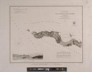
Cape Flattery to Neé-ah Harbor Washington Topography by G. Davidson Assistant U.S.C.S. Hydrography by the party under the command of Lieut. James Alden U.S.N. Assistant 1853
Rare Books
At head of title: U. S. Coast Survey A. D. Bache Superintendent The south side of the Strait of Juan de Fuca from the coast with vignette from the ocean. MS notes: E.J. Dup. MES 912.797. Prime meridian: GM. Relief: hachures. Graphic Scale: Miles. Projection: Plane. Printing Process: Engraving. Verso Text: MS note: 214372.
214372
Image not available
Preliminary survey of Point Reyes and Drake's Bay California / geographical positions by George Davidson, Assistant topography by J.S. Lawson, Sub-Assist hydrography by the party under the command of Lieut. J. Alden U.S.N. Assist
Visual Materials
No old shelf mark. At head of title: "(J. No. 6) U.S. Coast Survey A.D. Bache Supdt." For another edition, see RB 492434. Prime meridian: GM. Relief: hachures. Graphic Scale: Miles. Projection: Cylindrical. Printing Process: Lithography.
ephMPCALIF0234
Image not available
Preliminary Sketch of Santa Barbara California Topography / by A. M. Harrison, Sub Assistant Hydrography by the party under the command of Lieut. James Alden U.S.N. Assistant
Rare Books
At head of title: U. S. Coast Survey A. D. Bache Superintendent. Clear view of early Santa Barbara. Vignette: Town & Mission from the ocean. MS notes: E.J. Dup. MES 912.797 . Prime meridian: GM. Relief: hachures. Graphic Scale: Miles. Projection: Cylindrical. Printing Process: Engraving. Vignettes
214374