Rare Books
Preliminary Sketch of Santa Barbara California Topography / by A. M. Harrison, Sub Assistant Hydrography by the party under the command of Lieut. James Alden U.S.N. Assistant
You might also be interested in
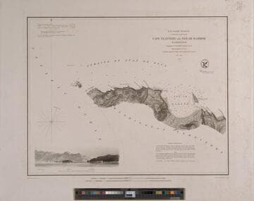
Cape Flattery to Neé-ah Harbor Washington Topography by G. Davidson Assistant U.S.C.S. Hydrography by the party under the command of Lieut. James Alden U.S.N. Assistant 1853
Rare Books
At head of title: U. S. Coast Survey A. D. Bache Superintendent The south side of the Strait of Juan de Fuca from the coast with vignette from the ocean. MS notes: E.J. Dup. MES 912.797. Prime meridian: GM. Relief: hachures. Graphic Scale: Miles. Projection: Plane. Printing Process: Engraving. Verso Text: MS note: 214372.
214372
Image not available
Preliminary Survey of Shoalwater Bay Washington / by the Hydrographic Party under the command of Lieut. James Alden U.S.N. Asst. 1853
Rare Books
At head of title: U. S. Coast Survey A. D. Bache Superintendent. Willapa Bay is north of the entrance to the Columbia River. MS notes: E.J. Dup. MES 912.797. Prime meridian: GM. Relief: hachures. Graphic Scale: Miles. Projection: Cylindrical. Printing Process: Engraving. Verso Text: MS note: 214371.
214371
Image not available
U. S. Coast Survey A. D. Bache Superintendent Reconnaisance of the Western Coast of the United States from Gray's Harbor to the Entrance of Admiralty Inlet by the Hydrographic Party under the command of Lieut. James Alden U.S.N. Asst. 1853
Rare Books
Northwest coast of Washington State. MS notes: E.J. Dup. MES 912.797. Four coastal vignettes: Cape Flattery; Flattery Rocks; Destruction Island; Pt. Grenville. Prime meridian: GM. Relief: hachures. Graphic Scale: Miles. Projection: Cylindrical. Printing Process: Engraving. Verso Text: MS note: 214373.
214373
Image not available
Preliminary survey of Point Reyes and Drake's Bay California / geographical positions by George Davidson, Assistant topography by J.S. Lawson, Sub-Assist. hydrography by the party under the command of Lieut. J. Alden, U.S.N. Assist
Rare Books
At head of title: "(J. No. 6) U. S. Coast Survey A. D. Bache, Supdt.1855. No. 47." For another edition, see HEH ephMPCALIF0234. Prime meridian: GM. Relief: hachures. Graphic Scale: Miles. Projection: Cylindrical. Printing Process: Lithography. Verso Text: MS note: 492434.
492434
Image not available
Reconnaissance of Catalina Harbor and the anchorage on the N. E. side of the island, California : by the hydrographic party under the command of Lieut. James Alden U.S.N. Assistant. 1852
Rare Books
At head of title: "U. S. Coast Survey A.D. Bache, Superintendent." See also RB 482852. This is now known as the Isthmus area of Catalina Island. Vignette: View of Catalina Harbor (from the south). MS notes : 613 100. Prime meridian: GM. Relief: hachures. Graphic Scale: Miles. Projection: Plane. Printing Process: Copper engraving.
492446
Image not available
Preliminary survey of San Pedro Anchorage and vicinity of Santa Barbara California / geographical position by G. Davidson Assist topography by A.M. Harrison Asst. & W.M. Johnson Sub Asst hydrography by the part under the command of Lieut. J. Alden U.S.N. Asst
Rare Books
Two maps on one sheet with different scales. At head of title: (J. No. 4) U. S. Coast Survey A. D. Bache, Supdt. RB copy : From the library of John Haskell Kemble. RB copy : Ink stamp of the U.S. Geological Survey Library, 1887, stamped on each map. RB copy : Housed in an envelope. Stamp: U.S. Geological Survey Library 1887. MS notes: 609. Prime meridian: GM. Relief: hachures. Graphic Scale: Miles. Projection: Cylindrical. Printing Process: Lithography. Verso Text: Ms note: 492435.
492435