Rare Books
Preliminary survey of San Pedro Anchorage and vicinity of Santa Barbara California / geographical position by G. Davidson Assist topography by A.M. Harrison Asst. & W.M. Johnson Sub Asst hydrography by the part under the command of Lieut. J. Alden U.S.N. Asst
You might also be interested in
Image not available
Preliminary survey of San Pedro anchorage and vicinity of Santa Barbara California / geographical positions by G. Davidson, Assist topography by A.M. Harrison Asst. & W.M. Johnson, Sub. Asst hydrography by the party under the command of Lieut. J. Alden U.S.N. Asst. 1855
Visual Materials
No old shelf mark. At head of title: "(J. No. 4) U.S. Coast Survey A.D. Bache, Supdt." Point Castillo is at the north end of the harbor at Santa Barbara Prime meridian: GM. Relief: hachures. Graphic Scale: Miles. Projection: Cylindrical. Printing Process: Lithography. Verso Text: MS note: Calif.
ephMPCALIF0229
Image not available
Preliminary survey of Point Reyes and Drake's Bay California / geographical positions by George Davidson, Assistant topography by J.S. Lawson, Sub-Assist. hydrography by the party under the command of Lieut. J. Alden, U.S.N. Assist
Rare Books
At head of title: "(J. No. 6) U. S. Coast Survey A. D. Bache, Supdt.1855. No. 47." For another edition, see HEH ephMPCALIF0234. Prime meridian: GM. Relief: hachures. Graphic Scale: Miles. Projection: Cylindrical. Printing Process: Lithography. Verso Text: MS note: 492434.
492434
Image not available
Monterey Harbor California : from a trigonometrical survey under the direction of A.D. Bache, Superintendent of the Survey of the Coast of the United States / triangulation by R.D. Cutts, Assistant ; topography by R.D. Cutts, Asst. and A.M. Harrison, Sub. Asst.; hydrography by the party under the command of Lieut. James Alden, U.S.N. Asst
Rare Books
Map by we the people. Vignette: View of Pt. Pinos. Stamp: Coast Geodetic Survey Office Jan 4 1886 Engraving Division. MS notes: Ed. 1852 617. Prime meridian: GM. Relief: hachures. Graphic Scale: Miles. Projection: Plane. Printing Process: Lithography.
492433
Image not available
Preliminary Sketch of Santa Barbara California Topography / by A. M. Harrison, Sub Assistant Hydrography by the party under the command of Lieut. James Alden U.S.N. Assistant
Rare Books
At head of title: U. S. Coast Survey A. D. Bache Superintendent. Clear view of early Santa Barbara. Vignette: Town & Mission from the ocean. MS notes: E.J. Dup. MES 912.797 . Prime meridian: GM. Relief: hachures. Graphic Scale: Miles. Projection: Cylindrical. Printing Process: Engraving. Vignettes
214374
Image not available
Preliminary survey of Point Reyes and Drake's Bay California / geographical positions by George Davidson, Assistant topography by J.S. Lawson, Sub-Assist hydrography by the party under the command of Lieut. J. Alden U.S.N. Assist
Visual Materials
No old shelf mark. At head of title: "(J. No. 6) U.S. Coast Survey A.D. Bache Supdt." For another edition, see RB 492434. Prime meridian: GM. Relief: hachures. Graphic Scale: Miles. Projection: Cylindrical. Printing Process: Lithography.
ephMPCALIF0234
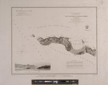
Cape Flattery to Neé-ah Harbor Washington Topography by G. Davidson Assistant U.S.C.S. Hydrography by the party under the command of Lieut. James Alden U.S.N. Assistant 1853
Rare Books
At head of title: U. S. Coast Survey A. D. Bache Superintendent The south side of the Strait of Juan de Fuca from the coast with vignette from the ocean. MS notes: E.J. Dup. MES 912.797. Prime meridian: GM. Relief: hachures. Graphic Scale: Miles. Projection: Plane. Printing Process: Engraving. Verso Text: MS note: 214372.
214372