Rare Books
Pennsylvania system
You might also be interested in

A Plan of the Posts of York and Gloucester in the Province of Virginia, Established by His Majesty's Army under the Command of Lieut. General Earl Cornwallis, together with The Attacks and Operations of the American and French Forces, Commanded by General Washington and the Count of Rochambeau, Which Terminated in the Surrender of the said Posts and Army, on the 17th of October 1781. / Surveyed by Captn. Fage of the Royal Artillery
Visual Materials
Kashnor notes, "Exceedingly rare, and only a few copies known. The slip map shows the position of the British lying across the Great South Road to Hampton, while the map shows the first and second parallel as Washington gradually closed in on Yorktown. This is probably the finest war plan of the action which swept away all hopes of the success of British arms, and was the crowning victory for American Independence." Contains submap of Chesapeake Bay. [Many characteristics of Des Barres maps, but map trimmed to neatline with no mention of author.] Submap: Chesapeake Bay and vicinity.. Relief: hachures. Graphic Scale: Feet. Projection: Plane. Printing Process: Copper engraving. Other Features: Sub-maps. Verso Text: MS note: 100.
105:1000 M

A Plan of the Posts of York and Gloucester in the Province of Virginia, Established by His Majesty's Army under the Command of Lieut. General Earl Cornwallis, together with The Attacks and Operations of the American & French Forces Commanded by General Washington and the Count of Rochambeau, Which Terminated in the Surrender of the said Posts and Army on the 17th of October 1781 / Surveyed by Captn. Fage of the Royal Artillery
Rare Books
An important map with no attribution but possibly by William Faden. An overlay shows the positions of the British forces on September 28th and 29th some two weeks prior to the surrender. The main map shows the British forces trapped in York itself and the redoubts and batteries set up by the American and French forces. The Charon is shown in flames in York harbor and French ships sit off Gloucester. The bulk of the French fleet is not shown, but blockaded the mouth of Chesapeake Bay, trapping the British army who then surrendered ending the American Revolutionary War. Submap: Overlay, showing British positions on Sept 28-29.. Prime meridian: Gm. Relief: shaded, hachures. Graphic Scale: Feet. Projection: Plane. Printing Process: Copper engraving. Other Features: Sub-maps.
268097
Image not available
New York Central Railroad
Rare Books
Map shows New York Railroad Company lines, leased lines, and nine (9) allied lines. Four inset maps show: New York City and Vicinity; Chicago and Vicinity; Boston and Vicinity; Buffalo, Niagara Falls and Vicinity. Map shows current lines and lines under construction. Prime meridian: GM. Relief: hachures. Graphic Scale: Miles. Projection: Polyconic. Printing Process: Lithography.
492466

Map exhibiting the Frontiers of Canada and the United States, intended to illustrate The Operation of the British & American Armies
Visual Materials
Kashnor notes, "A scarce map issued during the War of 1812." Submap of East Coast from St. Lawrence River to Chesapeake Bay. Submap: Sketch of the Coast of North America from the River St. Lawrence, to Chesapeake Bay. MS notes at top give positions of British and "Enemy" forces on 30th Oct (year uncertain).. Prime meridian: GM. Relief: no. Graphic Scale: Miles. Projection: Azimuthal. Printing Process: Engraving. Other Features: Sub-maps. Verso Text: CANADA.
093:245 M
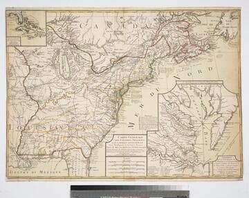
Carte Generale des Colonies Angloises dans L'Amerique Septentrionale Pour l'Intelligence de la Guerre Presente. D'apres des Manuscrit Anglais par J. B. Nolin Geographe. Corrigé Augmenté des indications des principaux énenemens de la Guerre avec le tracee des Limites pour constituer le traité de Paix proposé entre la Couronne de la Grande Bretagne Et les Etats unis. Par R. Phelipeau Géographe, Professeur de Mathematique et l'Ecole Royale Militaire de Londres 1783
Visual Materials
Proposed peace settlement lines shown. Submaps of Florida and Caribbean Islands, second submap of Chesapeake Bay area labeled: Suplément Qui represente la partie de la Virginie ou se trouvent le Theatre ou l'Armée Combinée des Francois et des Etats Unies a fait prisonnier le Geeneral Cornwalis Le 19 Octobre 1781 et le Plan d'attaque d'Yorck et de Glocester Par les Generaux Washington et Rochambeau. Le detail de la Baye de Chesapeake, par L. Denis... Many notes of battles fought during Revolutionary War. Submaps of Caribbean and Florida, Chesapeake Bay.. Prime meridian: Ferro. Relief: pictorial. Graphic Scale: Italian miles, Grand leagues, Common leagues, Journeys of Savages.. Projection: Pseudocylindrical. Watermark: Chain enclosed Maltese Cross. Printing Process: Copper engraving. Other Features: Sub-maps. References: McCorkle 783.18. Verso Text: MS note: 85.
093:085 M
Image not available
Missouri-Kansas-Texas lines
Rare Books
Map shows lines "owned and leased to other carriers" and "operated under trackage rights". Rail lines shown in red. Prime meridian: GM. Relief: no. Projection: Polyconic. Printing Process: Lithography.
492477