Rare Books
A Plan of the Posts of York and Gloucester in the Province of Virginia, Established by His Majesty's Army under the Command of Lieut. General Earl Cornwallis, together with The Attacks and Operations of the American & French Forces Commanded by General Washington and the Count of Rochambeau, Which Terminated in the Surrender of the said Posts and Army on the 17th of October 1781 / Surveyed by Captn. Fage of the Royal Artillery

You might also be interested in

A Plan of the Posts of York and Gloucester in the Province of Virginia, Established by His Majesty's Army under the Command of Lieut. General Earl Cornwallis, together with The Attacks and Operations of the American and French Forces, Commanded by General Washington and the Count of Rochambeau, Which Terminated in the Surrender of the said Posts and Army, on the 17th of October 1781. / Surveyed by Captn. Fage of the Royal Artillery
Visual Materials
Kashnor notes, "Exceedingly rare, and only a few copies known. The slip map shows the position of the British lying across the Great South Road to Hampton, while the map shows the first and second parallel as Washington gradually closed in on Yorktown. This is probably the finest war plan of the action which swept away all hopes of the success of British arms, and was the crowning victory for American Independence." Contains submap of Chesapeake Bay. [Many characteristics of Des Barres maps, but map trimmed to neatline with no mention of author.] Submap: Chesapeake Bay and vicinity.. Relief: hachures. Graphic Scale: Feet. Projection: Plane. Printing Process: Copper engraving. Other Features: Sub-maps. Verso Text: MS note: 100.
105:1000 M
Image not available
Colonial National Monument Yorktown Battlefield Virginia
Rare Books
A detailed view of the British, American and French forces but with no indication of the French fleet which sealed the fate of the British forces who laid their arms down on the Surrender Field. The verso contains map, photographs, and text about the area and the planned sesquicentennial. Relief shown by contours and spot heights. Contour interval 5 feet. Surveyed in 1930-1931. "Civil War fortifications shown by contours." Topography by K.W. Trimble, R.M. Wilson, J.M. Rawls, H.A. Bean, E.V. Holloway, J.O. Kilmartin, S.E. Clement, and G.A. Mock. Control by U.S. Geological Survey and U.S. Coast and Geodetic Survey Text, illus., and maps under title "The Colonial National Monument: Its History and present development" on verso On verso: Map of Yorktown Battlefield -- Aerial view Yorktown Sesquicentennial celebration area October 16, 17, 18 and 19, 1931 -- Yorktown Enlargement -- Approach highway map Colonial National Monument. Shows French, American and British positions. Imprint in lower margin at right. "Scale 1:9600 or 800 feet to 1 inch". At head of title: Department of the interior, U.S. Geological survey. Prime meridian: GM. Relief: contour lines. Graphic Scale: Miles, feet. Projection: Polyconic. Printing Process: Lithography. Verso Text: Text, maps and photos of the planned sesquicentennial area and the parkway linking Jamestown, Williamburg and Yorktown. MS note: 238375.
238373

Plan of the Siege of Charlestown in South Carolina
Visual Materials
Kashnor notes, "This shows Charlestown Harbour from Fort Sullivan to Charlestown Neck, and locating the positions of the British Fleet with the boom across Cooper's River. On the neck is shown the encampment of the British Forces, and the three parallels which eventually led to the fall of the town." The siege of Charleston ended May 12, 1779 with surrender to British forces. MS note: 72 (on backing). Relief: pictorial & hachures. Graphic Scale: Miles, furlongs. Projection: Plane. Printing Process: Copper engraving. Verso Text: MS note: 72 (on backing).
093:072 S
![Plan of the northern part of Rhode Island in the township of Portsmouth. Shewing the British posts of defence as compleated during the possession of Rhode Island, from the 8th of Dec. 1776 to the 25th of Oct. 1778. [cartographic material]](/_next/image?url=https%3A%2F%2Frail.huntington.org%2FIIIF3%2FImage%2F22APN4MO8O8O%2Ffull%2F%5E360%2C%2F0%2Fdefault.jpg&w=750&q=75)
Plan of the northern part of Rhode Island in the township of Portsmouth. Shewing the British posts of defence as compleated during the possession of Rhode Island, from the 8th of Dec. 1776 to the 25th of Oct. 1778. [cartographic material]
Manuscripts
Manuscript map showing the northern part of Rhode Island from Fogland Ferry to Bristol Point Ferry. The Battle of Rhode Island took place on August 29, 1778. This maps depicts the withdrawal of American troops northward on the island. Shows the roads from Newport leading north and shows the locations of the Hessian, Anspach, and British forces on Quaker Hill and the Continental Army positions on Wind-Mill Hill. The Continental Army held Wind-Mill Hill for 2 days, before evacuating the island completely on September 1, 1778. Colored.
mssHM 15473
![Plan of the Entrance of Chesapeak [sic] Bay, with James and York Rivers wherein is shown the Respective Positions (in the beginning of October) 1. of the British Army Commanded by Lord Cornwallis, 2. of the American and French Forces under General Washington, 3. and of the French Fleet under Count de Grasse](/_next/image?url=https%3A%2F%2Frail.huntington.org%2FIIIF3%2FImage%2F22APN4KVOGIE%2Ffull%2F%5E360%2C%2F0%2Fdefault.jpg&w=750&q=75)
Plan of the Entrance of Chesapeak [sic] Bay, with James and York Rivers wherein is shown the Respective Positions (in the beginning of October) 1. of the British Army Commanded by Lord Cornwallis, 2. of the American and French Forces under General Washington, 3. and of the French Fleet under Count de Grasse
Visual Materials
Kashnor notes, "Exceedingly rare War Plan of the final action in the War of Independence. It shows Cornwallis cooped up in York by the American Army, and in Gloucester by the combined forces of Colonials and French. The French Fleet of thirty-two vessels under De Grasse has closed the entrance to York River, and the French ships under Barras hold the entrance to James River, dominate Fort George, and guard Barwell's Ferry. Only a few copies of this plan are known. The victory of Washington was a terrible blow to England, and it is doubtful whether the publisher sold enough copies to pay for his trouble in engraving. In any case, few people in England would wish to keep the map to remind them of a great failure." Relief: no. Graphic Scale: Miles. Projection: Plane. Printing Process: Copper engraving. Verso Text: MS note: 152 (on backing).
105:152 M
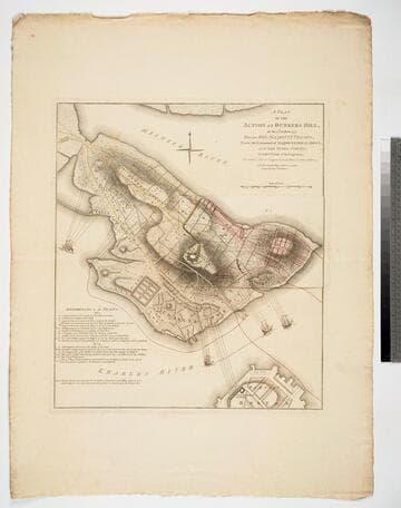
Plan of the Action at Bunkers Hill, on the 17th of June 1775, Between His Majesty's Troops, Under the Command of Major General Howe, and the Rebel Forces, by Lieut. Page of the Engineers, who acted as Aide de Camap to General Howe in that Action. NB. The ground plan is from an Actual Survey by Capt. Montresor
Visual Materials
Kashnor notes, "Of this map, no other complete copy can be traced. It was re-engraved for Stedman's History, but without the slip. The slip No. 1 is laid over that part of Bunker's Hill, which was in the hands of the colonists, and shows the first position of the English troops. The Colonial forces shown in yellow, the English in red. On lifting the slip there is shown the second position of the English forces, with the hill almost surrounded. In the Charles River the two warships Lively and Falcon are bombarding the hill, and off Charlestown Neck the armed transport is firing on the Colonial communications. A scale of reference is given, which relates to both the slip and the map. It is probable that this plan was never published, and only engraved for official use. There is no engraver or publisher, but a copy, evidently wanting the slip No. 1, is in the Library of Congress, where it is in the Faden Collection." Kashnor notes publication by [W. Faden, 1775]. Kashnor is incorrect on several points. Both Stedman's History and the later published Faden's Maps of the American War contain copies of this map, both with the flap or slip in place, or at least in the Huntington Library copies. Those copies do differ from this one. Each includes the words "To front Page 127, Vol. 1" above the neatline upper right corner. They are also marked below the title "Engraved for Stedman's History of the American War, Published by the Author, April 12, 1793." Slip or flap showing two positions of the English forces during the battle.. Relief: hachures. Graphic Scale: Yards. Projection: Plane. Watermark: Crowned fleur-di-lis WF. Printing Process: Copper engraving. Other Features: Sub-maps. Verso Text: M S note: 846.
093:846 M