Rare Books
A map of the mail coach, branching cross and bye post roads of Ireland : distinguishing at one view the arrival of the mails from and towards Dublin as also their departure or time of delay in passing each town and the distance from Dublin in miles and furlongs
You might also be interested in
Image not available
General survey of England and Wales : an entirely new & accurate survey of the county of Kent, with parts of the county of Essex / done by the Surveying Draughtsmen of His Majesty's Honorable Board of Ordnance, on the basis of the trigonometrical survey carried on by their orders under the direction of Captn. W. Mudge of the Royal Artillery, F.R.S
Rare Books
Alternate title from envelope. Dedication reads: "To the most noble Charles Marquis Cornwallis and the rest of the Principal Officers of His Majesty's Ordnance, this map is respectfully dedicated by their most obedient & faithful servant, W. Mudge, Drawing Room Tower, January 1st 1801." A large map in four sheets. Gift of the Friends. Prime meridian: GM. Relief: hachures. Graphic Scale: Miles. Projection: Cylindrical. Printing Process: Copper engraving.
474037
Image not available
Ortelius improved or a new map of Ireland : wherein are inserted the principal families of Irish and English extraction who possess'd that kingdom on the commencement of the seventeenth century
Rare Books
Dedication at top of page: "To the most high puissant & noble prince William Fitzgerald Duke of Leinster Marquis & Earl of Kildare Earl & Baron of Ophaly in the kingdom of Ireland Viscount Leinster of Taplow in the kingdom of Great Britain premier Duke Marquis Earl & Baron of the kingdom of Ireland governor of the county of Kildare this map is most gratefully inscribed by his Grace's most obedient servant Charles O'Conor Esqre." Vignette: Fitzgerald coat of arms. Prime meridian: London. Relief: no. Projection: Pseudocylindrical. Printing Process: Copper engraving.
357829
Image not available
Map of Nova Scotia or Acadia; with the Islands of Cape Breton and St. John's, from Actual Surveys by Capt. Montresor, Engr. 1768
Visual Materials
Kashnor notes, "A rare map. Dedicated to John Manners, Marquis of Granby, with emblematic engravings, trophies, etc. A very fine topographical map, indicating the parishes in St. John's, hills, rivers, soundings, sandbanks, &c." Kershaw identifies as the second state, supplies appeared in information. Elaborate dedication cartouche.. "To the Most Noble John Manners Marquis of Granby, Field Marshall & Commander in Chief of all His Majesty's Forces Master General of Ordnance, Colonel of His Majesty's Royal Regimt. of Horse Guards Blue, Honourable Privy Council: This Map with all Submission is most humbly inscribed by Your Lordship's most dutiful most obedient and devoted Servant John Montresor, Engineer." "J. Caldnall Sculp." Prime meridian: Ferro9. Relief: pictorial. Graphic Scale: Miles. Projection: Plane. Printing Process: Copper engraving. Other Features: Cartouche. References: Kershaw 793. Verso Text: MS notes: 610 10.
105:610 M
Image not available
Ireland : from the best authorities with distances in miles from Dublin
Rare Books
A table explains the various divisions of the country at that time along with population information. Submap: Dublin. Cartouche: Irish harp and other symbols. Prime meridian: GM. Relief: hachures. Graphic Scale: Miles. Projection: Cylindrical. Printing Process: Engraving.
348427
Image not available
A map of the Kingdom of Ireland : divided into provinces, counties and baronies shewing the archbishopricks, bishopricks, cities, boroughs, market towns, villages, barracks, mountains, lakes, bogs, rivers, bridges, ferries, passes also the great, the branch & the by post roads, together with the inland navigation &c. / by J. Rocque, Chorographer to His Majesty
Rare Books
Gift of Mrs. Homer Crotty, November 1991. Cartouche: Pastoral with nude. Submap: The Sea Coasts of Great Britain and Ireland. Prime meridian: London. Relief: pictorial. Graphic Scale: Miles. Projection: Cylindrical. Printing Process: Copper engraving. Verso Text: MS notes: Rocques Ireland 2 sheets 1794 6A 6B 12 493927(493937) corrected.
493937
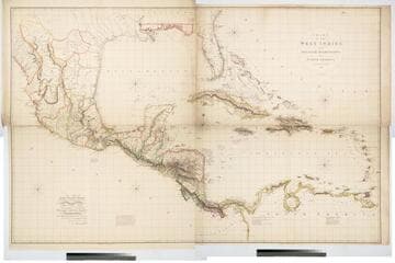
Chart of the West Indies and Spanish Dominions in North America. By A. Arrowsmith 1803
Visual Materials
Kashnor notes, "Amongst other interesting particulars, this map indicates the positions of the canals proposed to be cut by the Spaniards in 1528. The original issue of Arrowsmith's map, valuable for the detail regarding the coast of present-day Texas and the colonies of New Santander." " Jones Smith & Co. sc. Beaufort Build'gs Strand." "To Admiral John Willett Payne, A distinguished Native of the West Indies. Vice Admiral of the Coasts of Devonshire & Cornwall, Treasurer of Greenwich Hospital, Comptroller General of the Household of the Prince, &c., &c., &c. This chart is respectfully Dedicated by his most obedient Serv't A. Arrowsmith." Prime meridian: London. Relief: hachures. Projection: Cylindrical. Printing Process: Copper engraving. Verso Text: MS note: 795.
105:795 M