Rare Books
A plan of the town of Boston : with the intrenchments [sic] &ca. of His Majesty's forces in 1775 / from the observations of Lieut. Page of His Majesty's Corps of Engineers, and from those of other gentlemen
You might also be interested in
Image not available
Plan of the Town of Boston, with the Intrenchments &c. of His Majestys Forces in 1775: from the Observations of Lieut. Page of His Majesty's Corps of Engineers; and from the Plans of other Gentlemen
Rare Books
Kashnor notes, "A Rare War Plan. Two tables of references locate the redouts, bastions, blockhouses, batteries and fortified place, also the prominent building, including Christ Church, Old North Meeting, Faneuil Hall, Town Hall, Old Meeting, Old South Meeting, Trinity Church and New South Meeting. The Headquarters of General Clinton are located on Beacon St., those of General Burgoyne below Beacon Hill, Admiral Graves in Cow Lane, and General Howe in Milk Street." MS note: 845. Relief: hachures. Graphic Scale: Yards. Projection: Plane. Watermark: WF. Printing Process: Copper engraving. Verso Text: MS note: 845.
291462
Image not available
A new map of Ireland : civil and ecclesiastical / by the Revd. D.A. Beaufort L.L.D. Member of the Royal Irish Academy
Rare Books
"To His Majesty King George the Third, The Patron and Promoter of every useful science, This map is by His Majesty's gracious permission, most humbly and respectfully dedicated by the Author.""S. I. Neele Sculp. London.""Published as the Act directs March 1st, 1792 by Wm. Faden, Geographer to the King, Charing Cross London, and William Allen, Dublin."See RB 424970 : Memoir of a map of Ireland; illustrating the topography of that Kingdom, and containing a short account of its present state, civil and ecclesiastical; with a complete index to the map. By Daniel Augustus Beaufort ...Gift of Mrs. Homer Crotty June 1983. Cartouche: Cherubs with portrait of George III engraved by Neele.. Prime meridian: GM. Relief: hachures. Graphic Scale: Miles, Leagues. Projection: Polyconic. Printing Process: Copper engraving. Other Features: Cartouche. Verso Text: MS note: 481174 Sticker: Allen's Map & Print Warehouse Dublin..
481174
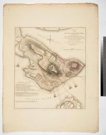
Plan of the Action at Bunkers Hill, on the 17th of June 1775, Between His Majesty's Troops, Under the Command of Major General Howe, and the Rebel Forces, by Lieut. Page of the Engineers, who acted as Aide de Camap to General Howe in that Action. NB. The ground plan is from an Actual Survey by Capt. Montresor
Visual Materials
Kashnor notes, "Of this map, no other complete copy can be traced. It was re-engraved for Stedman's History, but without the slip. The slip No. 1 is laid over that part of Bunker's Hill, which was in the hands of the colonists, and shows the first position of the English troops. The Colonial forces shown in yellow, the English in red. On lifting the slip there is shown the second position of the English forces, with the hill almost surrounded. In the Charles River the two warships Lively and Falcon are bombarding the hill, and off Charlestown Neck the armed transport is firing on the Colonial communications. A scale of reference is given, which relates to both the slip and the map. It is probable that this plan was never published, and only engraved for official use. There is no engraver or publisher, but a copy, evidently wanting the slip No. 1, is in the Library of Congress, where it is in the Faden Collection." Kashnor notes publication by [W. Faden, 1775]. Kashnor is incorrect on several points. Both Stedman's History and the later published Faden's Maps of the American War contain copies of this map, both with the flap or slip in place, or at least in the Huntington Library copies. Those copies do differ from this one. Each includes the words "To front Page 127, Vol. 1" above the neatline upper right corner. They are also marked below the title "Engraved for Stedman's History of the American War, Published by the Author, April 12, 1793." Slip or flap showing two positions of the English forces during the battle.. Relief: hachures. Graphic Scale: Yards. Projection: Plane. Watermark: Crowned fleur-di-lis WF. Printing Process: Copper engraving. Other Features: Sub-maps. Verso Text: M S note: 846.
093:846 M
Image not available
This map of Kentucke, drawn from actual observations, is inscribed with the most perfect respect to the Honorable the Congress of the United States of America and to his Excellcy. George Washington, late Commander in Chief of their Army / by their humble servant, John Filson
Visual Materials
No old shelf mark. MS note above neatline: "MS. Facs. of Filson's map of 1784." This photocopy of an MS copy of Filson's original map came from the Library of Congress as an exchange arranged by Linn R. Blanchard 5/29/30. Note says: "Filson's Discovery 2 maps. We have photostat (E128400) of this map on our copy of Filson (142577)." For a later version of the original (1793), see RB 105:468. Two stamps: Library of Congress Map Division Jan 6, 1908. April 19, 1930. Prime meridian: Philadelphia. Relief: pictorial. Graphic Scale: Miles. Projection: Cylindrical. Printing Process: photo reproduction.
ephMPKY0002
Image not available
Gen. Washington's revolutionary campaign war map : after a survey ordered by him, showing the position of his army in defence of Boston, 1776 also the fortifications and gun batteries extending from Charlestown around to Dorchester heights
Rare Books
A heliotype reproduction of an early map of Boston Harbor. MS note: 90789. Prime meridian: GM. Relief: hachures. Graphic Scale: Miles. Projection: Cylindrical. Printing Process: Heliotype reproduction.
90789
Image not available
Map of Texas and the countries adjacent : compiled in the Bureau of the Corps of Topographical Engineers ; from the best authorities ; for the State Department, under the direction of Colonel J.J. Abert, Chief of the Corps / by W.H. Emory, 1st. Lieut. T.E
Rare Books
The Texas Republic stretches from the Gulf of Mexico to the 42nd parallel in today's Wyoming. Authorities for the map are listed along with statistics for Texas. Table: Statistics, Population, Authorities. MS note: 43466. Prime meridian: GM, Washington. Relief: hachures. Graphic Scale: Miles. Projection: Pseudocylindrical. Printing Process: Lithography.
43466