Rare Books
Plan of the Town of Boston, with the Intrenchments &c. of His Majestys Forces in 1775: from the Observations of Lieut. Page of His Majesty's Corps of Engineers; and from the Plans of other Gentlemen
You might also be interested in
Image not available
A plan of the town of Boston : with the intrenchments [sic] &ca. of His Majesty's forces in 1775 / from the observations of Lieut. Page of His Majesty's Corps of Engineers, and from those of other gentlemen
Rare Books
Facsim. reproduction, possibly detached from a book, of map with ms. note in place of imprint: Engraved & printed for Wm. Faden, Charing Cross. Photo-reproduction of this map on Crane Co. paper. Original version: [London] : Wm. Faden, 1777. Prime meridian: GM. Relief: hachures. Projection: Polyconic. Printing Process: photocopy. Verso Text: MS note: 436641.
436641
Image not available
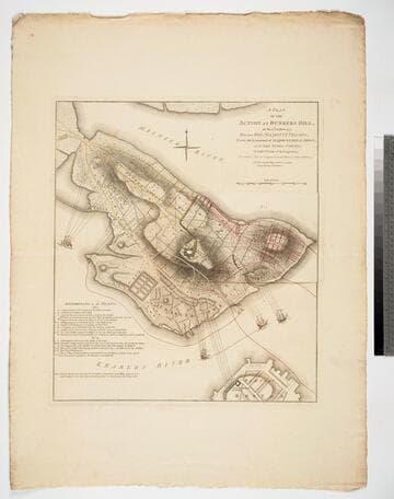
A plan of the action at Bunker's Hill, on the 17th of June 1775 : between His Majesty's troops, under the command of Maj. General Howe and the rebel forces / by Lieut. Page of the Engineers who acted as Aide de Camp to General Howe in that action
Visual Materials
No old shelf mark. An important map of the action by an eye witness. Probably published in London soon after the battle. View of Charlestown & from Beacon Hill, Boston. Plan of Redoubt & Co. on Bunker's Hill. from Gent. Mag. Relief: hachures. Graphic Scale: Yards. Projection: Plane. Printing Process: Copper engraving.
ephMPMASS0001
Plan of the Action at Bunkers Hill, on the 17th of June 1775, Between His Majesty's Troops, Under the Command of Major General Howe, and the Rebel Forces, by Lieut. Page of the Engineers, who acted as Aide de Camap to General Howe in that Action. NB. The ground plan is from an Actual Survey by Capt. Montresor
Visual Materials
Kashnor notes, "Of this map, no other complete copy can be traced. It was re-engraved for Stedman's History, but without the slip. The slip No. 1 is laid over that part of Bunker's Hill, which was in the hands of the colonists, and shows the first position of the English troops. The Colonial forces shown in yellow, the English in red. On lifting the slip there is shown the second position of the English forces, with the hill almost surrounded. In the Charles River the two warships Lively and Falcon are bombarding the hill, and off Charlestown Neck the armed transport is firing on the Colonial communications. A scale of reference is given, which relates to both the slip and the map. It is probable that this plan was never published, and only engraved for official use. There is no engraver or publisher, but a copy, evidently wanting the slip No. 1, is in the Library of Congress, where it is in the Faden Collection." Kashnor notes publication by [W. Faden, 1775]. Kashnor is incorrect on several points. Both Stedman's History and the later published Faden's Maps of the American War contain copies of this map, both with the flap or slip in place, or at least in the Huntington Library copies. Those copies do differ from this one. Each includes the words "To front Page 127, Vol. 1" above the neatline upper right corner. They are also marked below the title "Engraved for Stedman's History of the American War, Published by the Author, April 12, 1793." Slip or flap showing two positions of the English forces during the battle.. Relief: hachures. Graphic Scale: Yards. Projection: Plane. Watermark: Crowned fleur-di-lis WF. Printing Process: Copper engraving. Other Features: Sub-maps. Verso Text: M S note: 846.
093:846 M

Plan of the Attack on Fort Sulivan, near Charles Town in South Carolina, by a Squadron of His Majesty's Ships, on the 28th of June 1776, with the Dispostion of the King's Land Forces, and the Encampments and Entrenchments of the Rebels he from the Drawings made on the Spot Engraved by Wm. Faden
Visual Materials
Kashnor notes, "Very rare." See also 093-080M for another view of this battle. See 105:079S for duplicate copy. RLIN record may not include subtext from this map. Text of attack extracted from Letters of Sir Peter Parker and Lieut. General Clinton to the Lords of the Admiralty in letterpress below map. Inset map showing: Plan of the Platform in Sulivans Fort, by Lt. Colonel Thos. James of the Rl. Rt. of Artillery. MS note: 81. Relief: hachures. Graphic Scale: Miles. Projection: Plane. Watermark: Block IV. Printing Process: Copper engraving. Other Features: Sub-maps. Verso Text: MS notes: Mus. cat.#93 #81.
093:081 M

A New Plan of the Island of Grenada from The Original French Survey of Monsieur Pinel; Taken in 1763 by Order of Government, and now Published with the Addition of English Names, Alterations of Property and other Improvements to the Present Year 1796: by Lieut. Daniel Paterson, Assistant to the Quarter Master General of His Majesty's Forces
Visual Materials
Kashnor notes, "Dedicated to Lieut.-Gen. Robert Melvill, Governor-in-Chief of the Ceded Islands." Submap: Plan of the Twon of St. Georgr and Fort Royal.. Relief: hachures. Graphic Scale: Miles, paces. Projection: Plane. Printing Process: Copper engraving. Other Features: Sub-maps. Verso Text: MS notes: 403 22.
105:403 M

A Plan of the Posts of York and Gloucester in the Province of Virginia, Established by His Majesty's Army under the Command of Lieut. General Earl Cornwallis, together with The Attacks and Operations of the American and French Forces, Commanded by General Washington and the Count of Rochambeau, Which Terminated in the Surrender of the said Posts and Army, on the 17th of October 1781. / Surveyed by Captn. Fage of the Royal Artillery
Visual Materials
Kashnor notes, "Exceedingly rare, and only a few copies known. The slip map shows the position of the British lying across the Great South Road to Hampton, while the map shows the first and second parallel as Washington gradually closed in on Yorktown. This is probably the finest war plan of the action which swept away all hopes of the success of British arms, and was the crowning victory for American Independence." Contains submap of Chesapeake Bay. [Many characteristics of Des Barres maps, but map trimmed to neatline with no mention of author.] Submap: Chesapeake Bay and vicinity.. Relief: hachures. Graphic Scale: Feet. Projection: Plane. Printing Process: Copper engraving. Other Features: Sub-maps. Verso Text: MS note: 100.
105:1000 M