Rare Books
Fraser's travelling map of Ireland : shewing all the towns, lakes, rivers, roads and railways ; with the distances marked between all the towns, railway stations, and other important places
You might also be interested in
Image not available
Geological map of the British Isles and part of France : showing also the inland navigation by means of rivers and canals, the railways and principal roads and sites of the minerals ; under the patronage of His Royal Highness Prince Albert, to whom this map is by express permission humbly dedicated / I.A. Knipe
Rare Books
Four sheet map. Prime meridian: GM. Relief: no. Graphic Scale: Miles. Projection: Polyconic. Printing Process: Copper engraving.
476415
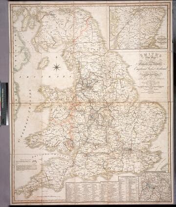
Smith's new map of the navigable canals and ri vers, of England, Wales & Scotland : distinctly shewing the length of each line, and the dates of the Acts of Parliament which have passed for executing the same ; containing also the direct roads to the principal places, with their distance from London
Rare Books
Alternate title from cover. A detailed map of the extensive network of canals and rivers crossing the UK in early 1800's. Submaps: Canals in the Environs of Birmingham; Continuation of Scotland including the Caledonian Canal. Table of principal canals with lengths. Prime meridian: GM. Relief: no. Graphic Scale: Miles. Projection: Polyconic. Printing Process: Engraving.
446560
Image not available
The tourist's pocket map of Pennsylvania : Exhibiting its internal improvements, road distances, &c. / by J. H. Young
Rare Books
Submaps: Vicinity of Philadelphia; Lehigh and Schuylkill Coal Regions; Profile of the Pennsylvania Canal. Prime meridian: GM, Washington. Relief: hachures. Graphic Scale: Miles. Projection: Polyconic. Printing Process: Copper engraving.
346169
Image not available
Canadian Pacific : railway, steamships, hotels, express, communications ; world's greatest travel system
Rare Books
Alternate title from cover. Prime meridian: GM. Relief: shaded. Graphic Scale: Miles. Projection: Polyconic. Printing Process: Lithography.
492528
Image not available
Bowles's new travelling map of England and Wales : exhibiting all the direct and principal cross roads ; with the distances in measured miles
Rare Books
Cartouche: Horse and vehicle. Prime meridian: London. Relief: no. Graphic Scale: Miles. Projection: Polyconic. Printing Process: Copper engraving. Other Features: Cartouche. Verso Text: MS notes: 474651 A B C D.
474651
Image not available
Cary's new map of Ireland : exhibiting the whole of the turnpike roads with the rivers and canals ; the market and borough towns and principal places adjoining the road to which is added the distances from one market town to another as well as from the metropolis
Rare Books
Alte title from cover; sales sticker on cover reads: "Sold by C. Smith. Mapseller, 172 Strand, London." Prime meridian: GM. Relief: hachures. Graphic Scale: Miles. Projection: Cylindrical. Printing Process: Copper engraving.
386441