Rare Books
Hosking's map of Pasadena and vicinity
You might also be interested in
Image not available
Map of Greater Pasadena District
Rare Books
This is a reduced size version of the map in the Pasadena Museum of History. Note that the Huntington Library is shown completed, indicating the date of publication as [193-]. "Compliments of Sierra Storage and Van Company 210 So. Raymond Ave. Pasadena California." Advertising at the top, street index at bottom of map. Relief: no. Graphic Scale: Miles. Projection: Plane. Printing Process: Lithography. Verso Text: Continued street index and additional advertising.
261044
Image not available
Map of Los Angeles County California : Completely indexed compiled from Official County and City Records and other sources / by American Surveys Incorporated
Rare Books
Wall map of county. Submaps: Central Business District; Marginal Map showing Santa Catalina Island and San Clemente Island Los Angeles County with reference to the mainland. Prime meridian: GM. Relief: hachures. Graphic Scale: Miles. Projection: Cylindrical. Printing Process: Blueline print.
268913
Image not available
Bridewell's map of northwest Los Angeles / compiled, copyrighted and sold by W.E. Bridwell Engineering Company
Rare Books
Blueline tract map of Hollywood area and south to Adams Boulevard. Note no Farmer's Market or Park La Brea Towers, or Hollywood Bowl. Prime meridian: GM. Relief: no. Graphic Scale: Feet. Projection: Plane. Printing Process: Blueline print. Verso Text: MS note: 477331 Sticker: L. A. Nw. Bridewell.
477331
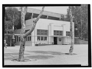
Rose Bowl Hall of Fame, Pasadena, California
Visual Materials
Exterior view of Rose Bowl Hall of Fame building at the Rose Bowl stadium in Pasadena, California. The stadium wall is seen in the background.
photCL_555_06_2119
Image not available
Map of territory annexed to the City of Los Angeles California / A.C. Hansen City Engineer
Rare Books
Notes annexations to Orange Cove in November 13, 1918. History table of annexations to 1918. Prime meridian: GM. Relief: hachures. Graphic Scale: Miles. Projection: Cylindrical. Printing Process: Blueline print. Verso Text: MS note: 381287.
381287
Image not available
Map of Portion of San Rafael Rancho and San Pasqual Rancho Compiled From The Records
Rare Books
Blueline map with Meridian St. (one block north of York Blvd.) to the south, Arroyo Seco to the east, Eagle Rock Rd. (now Figueroa St.) to the west, future Annandale Country Club to the north. Note Avenue 64 is named "Mountain Avenue," Colorado Blvd. is named "Eagle Rock Road," and Colorado St. Bridge does not exist, indicating a date prior to 1913. "Clarence P. Day - Civil Engineer." Relief: no. Graphic Scale: Feet. Projection: Plane. Printing Process: Blueline print.
381394