Rare Books
Map of Virginia, Gold Hill, Devils Gate, American Flat, gold & silver mining districts : state of Nevada / Higginson & Goldsworthy, Civil & Mining Engineers. Silver City, Nevada
You might also be interested in
Image not available
Map of the Treasure Hill silver mines, &c. White Pine Co., Nevada : compiled from the latest data and drawn by William Munt, Civil & Mining Engineer
Rare Books
Alt. title from cover. Submap: Silver Districts of Central Nevada. Prime meridian: GM. Relief: hachures. Graphic Scale: Miles. Projection: Cylindrical. Printing Process: Lithography.
41397
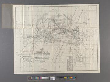
Map of the Comstock Brunswick and Flowery Lodes : showing the mining claims embraced in Virginia, Gold Hill, Devils Gate and Chinatown, Silver Star, American Flat and Flowery Districts. Lyon and Storey Counties Nevada 1923
Rare Books
Prime meridian: GM. Relief: hachures. Graphic Scale: Feet. Projection: Plane. Printing Process: Lithography.
290132
Image not available
Gold Placers of Upper Snake River with its tributaries : compiled from authentic public and private surveys / by Edmund Wilkes, Civil Engineer, U.S. Deputy Min. Surveyor
Rare Books
Alt. title from cover. Area south of Pocatello. Prime meridian: GM. Relief: hachures. Graphic Scale: Miles. Projection: Cylindrical. Printing Process: Lithography.
42008
Image not available
A new map of the states of California and Nevada : exhibiting the rivers, lakes, bays and islands, with the principal towns, roads, railroads and transit routes to the silver mining districts of Nevada Territory ; also meridian, standard, range and township lines as established ; to which is added the county boundaries and United States land districts ; carefully compiled from United States and other reliable surveys / by Leander Ransom
Rare Books
Alt. title from cover. Land districts shown by red lines with stairsteps. Prime meridian: GM. Relief: hachures. Graphic Scale: Miles. Projection: Cylindrical. Printing Process: Lithography.
41400
Image not available
A new map of the states of California and Nevada : exhibiting the rivers, lakes, bays and islands, with the principal towns, roads, railroads and transit routes to the silver mining districts of Nevada Territory ; also meridian, standard, range and township lines as established ; to which is added the county boundaries and United States land districts ; carefully compiled from United States and other reliable surveys / by Leander Ransom
Rare Books
Alt. title from cover. Land districts shown by red lines with stairsteps. Prime meridian: GM. Relief: hachures. Graphic Scale: Miles. Projection: Cylindrical. Printing Process: Lithography.
41399
Image not available
Map of the White Pine Mining District / compiled by A. Cadwalader
Rare Books
Submap: Map of the White Pine Range. Prime meridian: GM. Relief: hachures. Graphic Scale: Miles. Projection: Cylindrical. Printing Process: Lithography.
41392