Visual Materials
Map of Louisiana and of the River Mississipi by John Senex
You might also be interested in
Image not available
Map of Louisiana and of the River Mississipi by John Senex
Visual Materials
Kashnor notes, "The best of the early English maps, giving particulars of the West. The Mississippi is given with all its tributaries, the Red, Arkansas and Missouri Rivers, the last-named being shown with remarkable correctness, its course reaching to the north of the Rockies, where it is stated that the Spaniards ford the river to trade with the people to the North-West for "yellow iron." The map shows New Mexico, and locates Santa Fe." Kashnor dates as [1719]. New Orleans does not appear, same as on l'Isle map of same year. See 148964 for another copy, 093:429 for an apparently later copy. Cartouche: Around dedication. Prime meridian: London. Relief: pictorial. Graphic Scale: Leagues. Projection: Cylindrical. Watermark: Small fleur-di-lis. Printing Process: Copper engraving. Other Features: Cartouche. Verso Text: MS note: 558.
093:558 M
Image not available
A Map of Louisiana and of the River Mississipi by John Senex
Rare Books
Kashnor notes,"This is taken from Delisle's map. In the far north-west is engraved the Missouri passing north of the Rockies, with the inscription, 'The Indians say that near this place the Spaniards ford the river on Horse-back, going to treat with some nations lying to the northwest, whence they bring Yellow Iron, as they call it.' This gold came from California or Cariboo. A century afterwards Lewis and Clark followed the river until they could stand astride of it." Kashnor dates as [1719]. New Orleans does not appear, same as on l'Isle map of same year. See 093:558M for another copy and 093:429 for an apparently later copy. Cartouche: Around dedication. "This Map of the Mississipi is Most Humbly Inscribed to William Law of Lanreston Esq." Prime meridian: London. Relief: pictorial. Graphic Scale: Leagues. Projection: Cylindrical. Watermark: Small fleur-de-lis HD. Printing Process: Copper engraving. Other Features: Cartouche. Verso Text: MS note:703/105 025.
148964
Image not available
New Map of America From the latest Observations Revis'd by J. Senex
Visual Materials
McLaughlin dates 1719, provides appeared in information. Cartouche - Indians w. feathered headdresses, cannibals.. Prime meridian: London. Relief: pictorial. Projection: Pseudocylindrical. Watermark: Fleur di lis AB. Printing Process: Copper engraving. Other Features: Cartouche. References: McLaughlin 193; Wagner 520; Tooley 81; Leighly 155.. Verso Text: MS note: 193.
093:193 M
Image not available
New Map of the English Empire in the Ocean of America or West Indies. Revis'd by J. Senex
Visual Materials
One sheet with maps of six islands. Kashnor dates as ca. 1719. Submaps: Generall Chart of the West Indies; Barbados with St. Michaels or the Bridge Town; Bermudos; Tobago; Antego; St. Christophers; New Map of the Island of Jamaica; The Harour of Port Royall.. Relief: pictorial. Graphic Scale: Miles (each map). Projection: Plane. Watermark: Fleur-de-lis BA. Printing Process: Copper engraving. Other Features: Submaps.
093:727 M
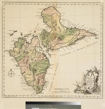
Guadaloupe one of the Caribbee Islands Subject to France in the West Indies, from the Best Authorities By T. Jefferys
Visual Materials
Kashnor dates as [1760]. RLIN record suggests 1768 and provides appeared in information. Cartouche: water falls & plants. Oversize binding spine still attached. Note: mile and league scales do not match.. Prime meridian: Ferro, London. Relief: pictorial & hachures. Graphic Scale: Miles, leagues. Projection: Cylindrical. Watermark: Crowned fleur-de-lis VI. Printing Process: Copper engraving. Other Features: Cartouche. Verso Text: MS notes: 93/775 148 La Guadaloupe La Guadalupe .
093:775 M
Image not available
Parte della Nuova Spagna, ò del Mexico doue sono le Provincie di Guadalaira Xalisco Mecoacan e Mexico Dedicata All'Illmo. Eccmo. Sigr. Nicolò Donà su de Sr. Nicolò dal Pre. Mro. Coronelli M. C. Cosmografo della Serenissima Republica di Venetia
Visual Materials
Kashnor dates as ca. 1690. This is a Nolin copy of Coronelli's map, published in Paris for the Italian market, so is probably from the mid 1700's. RLIN record suggests 1680 for publication date. Cartouche: crudely copied figures.. Prime meridian: Ferro. Relief: pictorial. Graphic Scale: Leagues. Projection: Cylindrical. Watermark: Circular device wit fleur-di-lis. Printing Process: Copper engraving. Other Features: Cartouche. Verso Text: MS note: 680.
093:680 M