Rare Books
Bowles's new one-sheet map of the Independent States of Virginia, Maryland, Delaware, Pensylvania, New Jersey, New York, Connecticut, Rhode Island &c.; comprehending also the habitations & hunting countries of the Confederate Indians / by Lewis Evans. Printed for the Proprietors Bowles & Carver, No. 69 in St. Pauls Church Yard, London

You might also be interested in

Bowles's new pocket map of the middle British Colonies, in America : viz. Virginia, Maryland, Delaware, Pensylvania, New Jersey, New York, Connecticut & Rhode Island ; comprending also the habitations & hunting countries of the Confederate Indians / by Lewis Evans. Printed for the proprietor Carington Bowles, No. 69 in St. Pauls Church Yard, London
Rare Books
This map is the same as 18219 with alteration of the title. Appears in "Bowles's Universal Atlas" undated, but with other maps dated 1780. It must have been issued before the Peace of 1782-3. Lake Huron extended northward, some streams added above Lakes Ontario and Erie, legend above Lake Erie removed. Submap: A sketch of the Remaining part of the Ohio R., &c. MS note: 18227. Prime meridian: London, Philadelphia. Relief: pictorial. Graphic Scale: Miles. Projection: Pseudocylindrical. Printing Process: Copper engraving. Verso Text: Stamped: XVI. MS notes: Shelve with #18212 Evans, Lewis ; #18227.
18227

Bowles's new pocket map of the following Independent States of North America : viz. Virginia, Maryland, Delaware, Pensylvania, New Jersey, NewYork, Connecticut & Rhode Island ; comprending also the habitations & hunting countries of the Confederate Indians / by Lewis Evans. Printed for the proprietor Carington Bowles, No. 69 in St. Pauls Church Yard, London
Rare Books
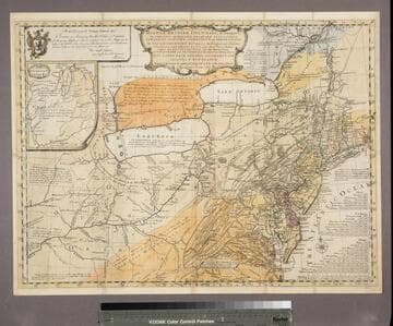
The first map to eliminate "Middle British Colonies" and replace it with "Independent States of North America." Made after the Peace of 1782-3, published in "Bowles's Universal Atlas" with maps dated 1784, this date is confidently assigned although the map is undated. New additions, Vermont and moving part of New Hampshire to the east of the Connecticut River. "Boundary of the United States" lettered in Lake Ontario, and the dotted line extended through Lakes Erie and Huron. The lettering of Canada remains below the border in this issue. Submap: A sketch of the Remaining part of the Ohio R., &c. MS note: 18228. Prime meridian: London, Philadelphia. Relief: pictorial. Graphic Scale: Miles. Projection: Pseudocylindrical. Printing Process: Copper engraving. Verso Text: Stamped: XVII. MS notes: Shelve with #18212 Evans, Lewis ; #18228.
18228

A general map of the middle British Colonies, in America : viz. Virginia, Maryland, Delaware, Pensilvania, New-Jersey, New York, Connecticut & Rhode Island ; of Aquanishuonigy, the country of the Confederate Indians comprehending Aquanishuonigy proper, their places of residence, Ohio & Thuchsochruntie their deer-hunting countries, Couchsachrage and Skaniadarade, their beaver-hunting countries ; of the Lakes Erie, Ontario and Champlain ; wherein is also shewn the antient & present seats of the Indian Nations ; carefully copied from the original publish'd at Philadelphia / by Mr. Lewis Evans
Rare Books
This map is the same as 18218 with alteration of the imprint and exact dating. The second 1771 issue is map 18220, bearing some alterations explained there. Submap: A sketch of the Remaining part of the Ohio R., &c. MS note: 18219. Prime meridian: London, Philadelphia. Relief: pictorial. Graphic Scale: Miles. Projection: Pseudocylindrical. Printing Process: Copper engraving. Verso Text: Stamped: VIII. MS notes: Shelve with #18212 Evans, Lewis ; #18219.
18219
A general map of the middle British Colonies, in America; viz Virginia, Màriland, Dèlaware, Pensilvania, New-Jersey, New-York, Connecticut, and Rhode Island: of Aquanishuonîgy, the country of the Confederate Indians; comprehending Aquanishounîgy proper, their place of residence, Ohio and Tïiuxsoxrúntie their deer-hunting countries, Couxsaxráge and Skaniadaráde, their beaver-hunting countries; of the Lakes Erie, Ontário and Champlain, and of part of New-France: wherein is also shewn the antient and present seats of the Indian Nations / by Lewis Evans 1755
Rare Books
Evans 1755 map is now landscape and includes more westerly parts of North America. A submap extends the course of the Ohio River to the Mississippi. Evans notes Fry and Jefferson's map of Virginia and notes agreement of Longitudinal observations with Thomas Godfrey. The "Analysis" referred to is a 32 page quarto written by Evans and printed by B. Franklin and D. Hall at Philadelphia in 1755 describing the country and boundaries. This map normally accompanied that publication. A copy of the Analysis accompanies the maps in the same folder, along with a copy of Pownall's 1776 "Topographical Description of North America." Submap: A sketch of the Remaining part of the Ohio R., &c. MS note: 18213. Prime meridian: London, Philadelphia. Relief: pictorial. Graphic Scale: Miles. Projection: Pseudocylindrical. Printing Process: Copper engraving. Verso Text: Stamped: II. MS notes: Shelve with #18212 Evans, Lewis ; #18213.
18213

A general map of the middle British Colonies, in America : viz. Virginia, Maryland, Delaware, Pensilvania, New-Jersey, New-York, Connecticut, and Rhode-Island ; of Aquanishuonigy the country of the Confederate Indians, comprehending Aquanishuonigy proper, their places of residence, Ohio and Thuchsochruntie their deer hunting countries, Couchsahrage and Skaniadarade, their beaver-hunting countries ; of the Lakes Erie, Ontario and Champlain, exhibiting the antient and present seats of the Indian Nations / published by Mr. Lewis Evans at Philadelphia ; corrected and improved with the additions of the line of forts on the back settlements, by Thos. Jefferys Geographer to the King
Rare Books
This is a reissue of the Jefferys map of 1758 with considerable alteration. New France is dropped from the title but "Part of New France" remains on the map itself. The scale is slightly different but may simply be differences in paper shrinkage. Stevens suggests this map was issued as a separate sometime between 1763 and 1768, then included as part of "A General Topography of North America", published by R. Sayer & T. Jeffereys in 1768. Submap: A sketch of the Remaining part of the Ohio R., &c. MS note: 18217. Prime meridian: London, Philadelphia. Relief: pictorial. Graphic Scale: Miles. Projection: Pseudocylindrical. Printing Process: Copper engraving. Verso Text: Stamped: VI. MS notes: Shelve with #18212 Evans, Lewis ; #18217.
18217

A general map of the middle British Colonies, in America : viz. Virginia, Maryland, Delaware, Pensilvania, New-Jersey, New York, Connecticut & Rhode Island ; of Aquanishuonigy the country of the Confederate Indians comprehending Aquanishuonigy proper, their places of residence, Ohio & Thuchsochruntie their deer-hunting countries, Couchsachrage and Skaniadarade, their beaver-hunting countries, of the Lakes Erie, Ontario and Champlain ; wherein is also shewn the antient & present seats of the Indian Nations ; carefully copied from the original publish'd at Philadelphia / by Mr. Lewis Evans
Rare Books
This map is referred to in Stevens as a second edition of Carington Bowles map number 18219. Differences include: CANADA in 5/16 inch letters across upper section. Connecticut River extended north to 45°. Tentative boundary with Canada shown by colored line. Date unchanged from 18219. Publication date assigned because in 1774 the boundary with Canada was under debate in Parliament. Many notes regarding various Indian tribes and relations with French claims north of the Ohio River. Sub map: A Sketch of the Remaining Part of the Ohio R. &c. MS note:18220. Prime meridian: GM, Philadelphia. Relief: pictorial. Graphic Scale: Miles. Projection: Conic. Printing Process: Copper engraving.
18220