Rare Books
Indicator Map of London : divided into quarter mile squares for measuring distance
You might also be interested in
Image not available
Indicator map London with the recent improvements
Rare Books
Alternate title from cover. With measuring tape bound in. Prime meridian: GM. Relief: no. Graphic Scale: Miles. Projection: Cylindrical. Printing Process: Lithography. Verso Text: Sticker - Henry F. Gillig & Co. MS notes: Maps Smith, Charles, of London scarce.
437699
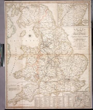
Smith's new map of the navigable canals and ri vers, of England, Wales & Scotland : distinctly shewing the length of each line, and the dates of the Acts of Parliament which have passed for executing the same ; containing also the direct roads to the principal places, with their distance from London
Rare Books
Alternate title from cover. A detailed map of the extensive network of canals and rivers crossing the UK in early 1800's. Submaps: Canals in the Environs of Birmingham; Continuation of Scotland including the Caledonian Canal. Table of principal canals with lengths. Prime meridian: GM. Relief: no. Graphic Scale: Miles. Projection: Polyconic. Printing Process: Engraving.
446560
Image not available
Map of Greater Los Angeles America's Largest Publisher of Street Maps Operations Engineers in Charge George E. Frank, Clyde A. Hollenbeck, Milton N. Rosenbaum, Julius F. Wilke, Western Mgr
Rare Books
At head of title: "Hearne Brothers Present Polyconic Projection." Rolled wall map. Attached cloth tape for locating streets with hub point of Farmers Market. "A big mechanical index, showing the exact location of more than 15,000 different street names, will be found on the reverse side of this map." This map shows no trace of the Arroyo Parkway opened in January 1941, hence is probably earlier. Film covered. Relief: no. Graphic Scale: Miles. Projection: Polyconic. Printing Process: Lithography. Verso Text: Printed street gazetteer.
381285
Image not available
Cruchley's Handy Map of London. Published by Gall & Inglis, 25 Paternoster Square, London & Edinburgh
Rare Books
Alt. title from cover. Map is enclosed with booklet of places of interest and index of streets. Dates based on: 1) the Peoples' Palace in Mile End Road was founded in 1887, and are included in the pamphlet; 2) the National Portrait Gallery was housed in the Bethnal Green Museum from 1885 to 1896, when it moved to its current location in St. Martin's Place. Prime meridian: GM. Relief: no. Graphic Scale: Miles. Projection: Cylindrical. Printing Process: Lithography.
319418

City views : collection of 43 city maps
Rare Books
Possibly reprints of some of the maps published "under the superintendence of The Society for the Diffusion of Useful Knowledge, 1830 - 1844, in its "Maps of the Society" (1844) and its "General atlas" (1853); cf. Phillips, #794 and #811; maps themselves dated 1830-1842. Title from spine of outer case. Map imprints list as publishers: Baldwin and Cradock (30, 1830-1837), Charles Knight & Co. (3, 183[8?]-1840); Society for the Diffusion of Useful Knowledge (8, 1838-1840), Chapman and Hall (2, 1842); one (Hamburg) is without imprint. All 41 x 36 cm. except the maps for Venice (in two parts) and London, which are 41 x 66 cm. Most include pictorial insets. 25 of these listed as drawn by W.B. Clarke, 15 as engraved by B.R. Davies, 13 as engraved, drawn and/or printed by J. Henshall; and 1-3 each as engraved and/or printed by J. & C. Walker and 6 others. Most maps are of European cities, except for: Calcutta. Also includes Pompeii, Rome (ancient) as well as Rome (modern). Many map captions include French, German or Italian listings, depending on location of city. RB copy IMPERFECT? Of the 50 maps listed in Phillips, this collection does not include: Amsterdam, Canton and approaches, London & environs, Paris & environs, Philadelphia, New York, Vienna.
496717
Image not available
A correct map of Ireland : divided into it's provinces, counties, and baronies shewing the roads and the distances of places in computed miles by inspection, where barraques are erected &c. London. Printed and Sold by Thos. Jefferys Geographer to his Royal Highness the Prince of Wales at the corner of St. Martins Lane in the Strand, and by W. Herbert on London Bridge. 1749
Rare Books
Gift of Mrs. Homer Crotty, November 1991. Cartouche: Putti; Harp. Prime meridian: London. Relief: pictorial. Graphic Scale: Miles. Projection: Pseudocylindrical. Printing Process: Copper engraving. Verso Text: MS notes: Ireland A.D. 1749 1749 493940.
493940