Rare Books
Map of the Gold Hill Front Lodes on the Comstock Range N. T. Surveyed July 1864. by N. Wescoatt, C.E. Located Sept. & Oct. 1859. Made to accompany Report of Dr. J. A. Veatch. Attenh. N. Wescoatt, C.E
You might also be interested in
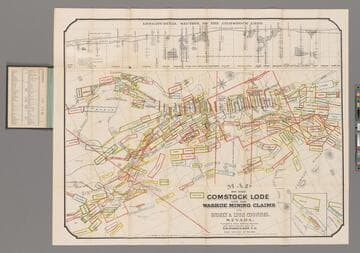
Map of the Comstock Lode and the Washoe Mining Claims in Storey & Lyon Counties, Nevada / Compiled from Official Surveys and other reliable data by T. D. Parkinson, C.E
Rare Books
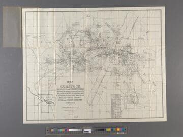
Longitudinal Section of the Comstock Lode. Prime meridian: GM. Relief: hachures. Graphic Scale: Feet. Projection: Plane. Printing Process: Lithography. Verso Text: MS note: 240738.
240738
Map of the Comstock Brunswick and Flowery Lodes : showing the mining claims embraced in Virginia, Gold Hill, Devils Gate and Chinatown, Silver Star, American Flat and Flowery Districts. Lyon and Storey Counties Nevada 1923
Rare Books
Prime meridian: GM. Relief: hachures. Graphic Scale: Feet. Projection: Plane. Printing Process: Lithography.
290132
Image not available
Map of Virginia City and the Comstock Lode State of Nevada, showing the latest changes up to Jan 1st 1875. Compiled and drawn by Edw. B. LaSalle, Topog. Engineer. 1875
Rare Books
Prime meridian: GM. Relief: hachures. Graphic Scale: Feet. Projection: Plane. Printing Process: Lithography.
245584
Image not available
The Comstock Lode : A Map
Rare Books
"Showing the original Comstock Lode and the East (or Bonanza) Ledge, wherein have recently been found the vast deposits of rich Gold and Silver Ore, with all the Locations of all Principal Mines, From American Flat (south of Gold Hill) to north-east of Virginia City, a distance of two miles." Printed on pink stock. MS notes: [San Francisco] 1870? 10321. Prime meridian: GM. Relief: no. Graphic Scale: Feet. Projection: Plane. Printing Process: Lithography. Verso Text: MS note: UE.
10321
Image not available
Map Comstock Lode / J. H. G. Wolf, 1911, Member American Society of Civil Engineers, San Francisco, California
Rare Books
Detailed map of the area under Virginia City, Nevada with sections to show mining activity between 1859 and 1910. Submaps: Three sectional elevations. Prime meridian: GM. Relief: pictorial & hachures. Graphic Scale: Feet. Projection: Plane. Printing Process: Blue Line Print. Verso Text: MS note: 308264 (var.) Comstock Lode Nev.
308264