Rare Books
Map of part of the Thousand Islands of the St. Lawrence River near Alexandria Bay, N.Y
You might also be interested in
Image not available
Maps of the city, county, bay and island of Galveston, Texas / by W.C. Willits, Civil Engineer
Rare Books
Table of elevations of intersections shows heights from 4 to 8 feet above sea level. Submaps: Galveston Island; Galveston County. Prime meridian: GM. Relief: no. Graphic Scale: Miles, feet. Projection: Plane. Printing Process: Lithography.
477791

A Chart of Cape Breton and St. John's Islands &c. in the Gulph of St. Lawrence
Visual Materials
Kashnor notes, "Includes Magdalen Islands, and part of the north coast of Nova Scotia as far beast as Chedabucto Bay." St John's Island shows property lines. Kashnor dates ca. 1750. Kershaw supplies appeared in information, author, and dates as 1777-81. Prime meridian: GM. Relief: hachures. Graphic Scale: Miles. Projection: Plane. Watermark: J. Whatman. Printing Process: Copper engraving. References: Kershaw 601. Verso Text: MS notes: 594 4.
105:594 M
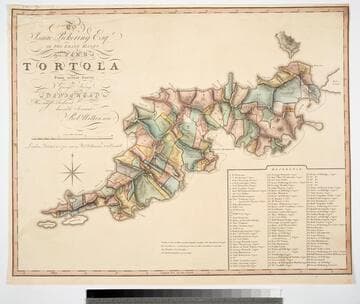
To Isaac Pickering Esqr of Fox Lease Hants this Plan of Tortola From actual Survey by George King is dedicated by His most obedient humble Servant Robt. Wilkinson
Visual Materials
Kashnor notes, "With a list of 104 plantations indicated on plan, with owners names." Pickering held the westernmost point of this island in the British Virgin Islands. Reference table listing owners and parcel numbers. MS note: 843 29. Prime meridian: GM. Relief: hachures. Graphic Scale: Miles, chains. Projection: Plane. Printing Process: Copper engraving. Verso Text: MS note: 843.
093:843 M
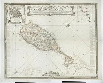
A New and Exact Map of the Island of St. Christopher in America
Visual Materials
One map on four sheets. Cartouche: Vined columns. Jams. Mynde Sculp. Dedication: Military decorations. Table: An Alphabetical List of the Subscribers Names. Submap: The Leeward Caribee Islands. Table of areas of each Parish.. "According to an Actual and Accurate Survey made in the Year 1753. Describing the several Parishes with their respective limits, Contents, & Churches, also the high ways, the Situation of every Gentleman's Plantation, Mills and Houses; with the Rivers, and Gutts. Likewise the Bays, Roads, Rocks, Shoals and Soundings that Surround the Whole. By Saml. Baker Lieutenant in His Majesty's Navy." "To the Right Honble. The Lords Commissioners for Executing the Office of Lord High Admiral of Great Britain &c. This map is most humbly Dedicated By their Lordships most Obedient humble Servt. Saml. Baker." Relief: pictorial. Graphic Scale: Miles. Projection: Plane. Printing Process: Copper engraving. Verso Text: MS notes: 7, 8, 9, 10 778 four sheets.
105:778 M
Image not available
Map of the Kern River oil field
Rare Books
Shows various owners of blocks extending north to Bakersfield and into Oildale. MS notes: blue circles, two locations. Prime meridian: Gm. Relief: no. Graphic Scale: Miles. Projection: Plane. Printing Process: Lithography. Verso Text: MS note: 252635.
252635
Image not available
A New Chart of the Gulf of St. Lawrence
Visual Materials
Submap and lat-long table. Published separately per Kershaw. Cartouche with walruses. Submap: Mingan and Esquimaux Islands Enlarged. Views: Gaspe Peninsula; Capes of Nova Scotia. Table of latitude and longitude for towns and points.. "Compiled from the Original Drawings of Actual Surveys; preserving the Natural Configuration of the Several Coasts & Headlands; The whole Adjusted by Astronomical Observations, by Thos. Wright, Surveyor General of the Island of St. John. 1790" Prime meridian: GM. Relief: no. Graphic Scale: Leagues. Projection: Mercator. Printing Process: Copper engraving. Other Features: CartoucheSub-mapsVignettes. References: Kershaw 615. Verso Text: MS notes: 786 10 1st. 2d..
105:786 M