Rare Books
A Map of Exploration in the Spanish Southwest 1528-1793
You might also be interested in
Image not available
Map of the landforms of the United States : to accompany Atwood's "Physiographic Provinces of North America"; prepared at the Institute of Geographical Exploration, Harvard University, Cambridge Mass. / by Erwin Raisz
Rare Books
A large number of descriptive notes cover this map. Prime meridian: GM. Relief: pictorial & hachures. Graphic Scale: Miles, kilometers. Projection: Polyconic. Printing Process: Lithography.
487818
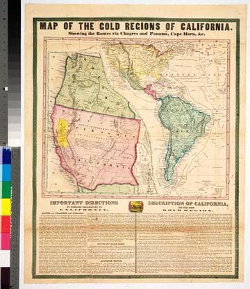
Map of the gold regions of California : showing the routes via Chagres and Panama, Cape Horn, &c
Rare Books
No marks as to maker or publisher, below the map are "Important Instructions" to person planning to use the various routes and another section "Description of California." Because a number of rivers are fairly accurately described the date would appear to be late 1849 or 1850. The map is described and the publisher identified in Carl I. Wheat's Mapping the Transmississippi West, volume 3, page 78, map 609. The map is divided in two sections, one showing an expanded California and Oregon with the Gold Region in yellow; the second showing routes from New York to California and including all of South America. Descriptive tables below map. MS note: 43465. Prime meridian: Washington DC. Relief: hachures. Projection: Pseudocylindrical. Printing Process: Lithography.
43465
Image not available
A New Map of the Whole Continent of America, divided into North and South and West Indies. wherein are exactly described the United States of North America as well as the Several European Possessions, according to the Preliminaries of Peace signed at Versailles Jan. 20. 1783. Compiled from Mr. D'Anville's Maps of that Continent, with the addition of the Spanish Discoveries in 1775 to the North of California & corrected in the Several Parts belonging to Great Britain, from the Original Materials of Governor Pownall, M.P
Visual Materials
Kashnor's notes do not match this map. This map is a later version of the Sayer & Bennett map of 1777, see 093:199M, also 093:218M for 1786 version. Insert map of Baffin's and Hudson's Bays. This map now shows Vancouver Island and corrects the River of the West, adding more exact information about the Pacific Northwest. The provisions of the 1763 Versailles treaty are removed, and instead the "Preliminaries of Peace signed at Versailles Jan 20,1783" are noted. Maine's border revised. See also 150262 (MBS 105:050). Cartouche w. alligator. Table delineating possessions of European nations now revised to include United States information Submap: The Supplement to North America containing the countries adjoining Baffins & Hudsons Bays.. Prime meridian: Ferro. Relief: pictorial. Graphic Scale: Miles, leagues. Projection: Pseudocylindrical. Watermark: IV RG Crowned fleur di lis. Printing Process: Copper engraving. Other Features: CartoucheSub-maps. Verso Text: MS notes: 28 29 199.
105:269 M

A map of ye English Empire in ye continent of America : viz Virginia, Mary Land, Carolina, New York, New Iarsey, New England, Pennsilvania. Sold by R. Morden at ye Atlas in Cornhill neer ye Royal Exchange London. W.Binneman sculpsit
Rare Books
Alternate title from head of text. This is state 2 of the map, as identified by Burden. See 71000 for a reproduction of the 2nd state of this map, 70999 for a reproduction of the 1st state of this map. Surround with many notes, starting "The designe of this map is to divert one common and notorious Abuse that the Dutch and French (whose Maps being the fondlings of this age) have imposed upon us..." Folder also contains a rather comprehensive description of the map addressed to Chester M. Cate, Huntington Library from Henry N. Stevens, Map and Book dealer, London. Submap: Virgina south to Florida. MS note: X71005. Prime meridian: GM. Relief: pictorial. Graphic Scale: Miles. Projection: Pseudocylindrical. Printing Process: Copper engraving. References: Burden, map 514. Verso Text: MS note: 71005.
71005
Image not available
A New Map of the Whole Continent of America, divided into North and South and West Indies
Rare Books
This map is a later version of the Sayer & Bennett map of 1777, see 093:199M, also 093:218M for 1786 version. Insert map of Baffin's and Hudson's Bays. This map now shows Vancouver Island and corrects the River of the West, adding more exact information about the Pacific Northwest. The provisions of the 1763 Versailles treaty are removed, and instead the "Preliminaries of Peace signed at Versailles Jan 20,1783" are noted. Maine's border revised. Kashnor notes, "One of the earliest maps to show the discoveries of Vancouver, locating the island bearing his name, and the Columbia River. Shows Nootka Sound. The map was issued at a time when the troubles over the Nootka question had lately been settled." This map duplicates 105:269. Cartouche w. alligator. Table delineating possessions of European nations now revised to include United States information Sub-map: The Supplement to North America containing the countries adjoining Baffins & Hudsons Bays. "Compiled from Mr. D'Anville's Maps of that Continent, with the addition of the Spanish Discoveries in 1775 to the North of California & corrected in the Several Parts belonging to Great Britain, from the Original Materials of Governor Pownall, M.P." Prime meridian: Ferro. Relief: pictorial. Graphic Scale: Miles, leagues. Projection: Pseudocylindrical. Printing Process: Copper engraving. Other Features: Cartouche Sub-maps. Verso Text: MS notes: 35 36 50 150262.
150262
Image not available
A New Map of the Whole Continent of America, divided into North and South and West Indies
Rare Books
This map is a later version of the Sayer & Bennett map of 1777, see 093:199M, also 093:218M for 1786 version, 105:269 for a duplicate. Insert map of Baffin's and Hudson's Bays. This map now shows Vancouver Island and corrects the River of the West, adding more exact information about the Pacific Northwest. The provisions of the 1763 Versailles treaty are removed, and instead the "Preliminaries of Peace signed at Versailles Jan 20,1783" are noted. Maine's border revised. See also 150262 (MBS 105:050). Cartouche w. alligator. Table delineating possessions of European nations now revised to include United States information Sub map: The Supplement to North America containing the countries adjoining Baffins & Hudsons Bays. "Compiled from Mr. D'Anville's Maps of that Continent, with the addition of the Spanish Discoveries in 1775 to the North of California & corrected in the Several Parts belonging to Great Britain, from the Original Materials of Governor Pownall, M.P." Prime meridian: Ferro. Relief: pictorial. Graphic Scale: Miles, leagues. Projection: Pseudocylindrical. Watermark: IV RG Crowned fleur di lis. Printing Process: Copper engraving. Other Features: Cartouche Sub-maps. Verso Text: MS notes: 28 29 150261 (sheet 1 & 2).
150261