Rare Books
Nuova California (Stati Uniti dell' America Settentrionale)
You might also be interested in
Image not available
L'America Settentrionale
Rare Books
Kashnor notes, "A scarce map, showing California as an island, locating Drakes port, also showing Santa Fe and Taos in New Mexico. McLaughlin explains: this is a copy of Sanson's 1650 map. The first Italian version was printed in 1669, this is the second state printed in 1687. Foliated with cannibals. "Nuouamente corretta, et accresciata secondo le relationi piu moderne, da Guglielmo Sansone Geographo di S. M. Christianisa." "Giorgio Widman Sculp." Prime meridian: Ferro. Relief: pictorial. Projection: Pseudocylindrical. Watermark: Circular seal. Printing Process: Copper engraving. Other Features: Cartouche. References: McLaughlin 65. Verso Text: MS notes: 156 Cat. 93 139315.
139315
Image not available
Parte della Nuova Spagna, ò del Mexico doue sono le Provincie di Guadalaira Xalisco Mecoacan e Mexico Dedicata All'Illmo. Eccmo. Sigr. Nicolò Donà su de Sr. Nicolò dal Pre. Mro. Coronelli M. C. Cosmografo della Serenissima Republica di Venetia
Visual Materials
Kashnor dates as ca. 1690. This is a Nolin copy of Coronelli's map, published in Paris for the Italian market, so is probably from the mid 1700's. RLIN record suggests 1680 for publication date. Cartouche: crudely copied figures.. Prime meridian: Ferro. Relief: pictorial. Graphic Scale: Leagues. Projection: Cylindrical. Watermark: Circular device wit fleur-di-lis. Printing Process: Copper engraving. Other Features: Cartouche. Verso Text: MS note: 680.
093:680 M
Image not available
An Accurate Map of North America
Rare Books
Two sub maps: A Particular Map of Baffin and Hudson's Bay; The Passage by Land to California Discover'd by Father Eusebius Francis Kino.. Voluminous text regarding sections of the treaty and other explanatory details. RLIN record gives appeared in information. Note this is a later printing of the map 093:146 in the Museum Bookstore collection, and is designated 093:147. "Describing and distinguishing the British and Spanish Dominions on this great Continent; according to the Definitive Treaty Concluded at Paris 10th Feby. 1763. Also all the West India Islands belonging to and possessed by the several European Princes and States." "The whole laid down according to the latest and Most authentick Improvements, by Emanuel Bowen, Geogr. to His Majesty And John Gibson Engraver." Elaborate cartouches, on title and scale. Two sub maps. Prime meridian: London, Ferro. Relief: pictorial. Graphic Scale: Miles, leagues. Projection: Pseudocylindrical. Watermark: Crowned fluer-di-lis. Printing Process: Copper engraving. Other Features: Cartouche Sub-maps. Verso Text: MS notes: 149502 147 cat 93 2 sheets [printed] 5 6.
149502
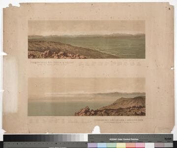
Panorama delle Alpi carniche e goriziane preso da Opcina presso Trieste Panorama der venetianischen u. görzischen Alpen vom Triangulirungspuncte Opcina bei Triest
Rare Books
Kirkpatrick Catalogue entry: "2509 Club Alpino Austro-Germanico. Sezione di Trieste. Panorama delle Alpi carniche e goriziane preso de Opcina presso Trieste. Vienna, Stamperia di Corte ed Instituto artistico di. G. Reiffenstein., [18--]. 1 sheet. [see cabinet]."The peaks and towns are numbered with a key at the bottom given their names and, in case of the mountains, their heights.Das deutscher und oesterreichischer Alpenvereins was formed on January 1st 1874 by the merging of the German Alpine Club and the Austrian Alpine Club (Brockhaus' Conversations-Lexikon: allgemeine deutsche Real-Encyklopädie, F.A. Brockhaus, Leipzig, 1882, volume 1, page 479). The end date provided is the year Burton died. MS notes: Burton (map cabinet) Club Alpine 2509. Printing Process: Lithography.
623683
Image not available
A New Map of the Whole Continent of America, divided into North and South and West Indies
Rare Books
This map is a later version of the Sayer & Bennett map of 1777, see 093:199M, also 093:218M for 1786 version, 105:269 for a duplicate. Insert map of Baffin's and Hudson's Bays. This map now shows Vancouver Island and corrects the River of the West, adding more exact information about the Pacific Northwest. The provisions of the 1763 Versailles treaty are removed, and instead the "Preliminaries of Peace signed at Versailles Jan 20,1783" are noted. Maine's border revised. See also 150262 (MBS 105:050). Cartouche w. alligator. Table delineating possessions of European nations now revised to include United States information Sub map: The Supplement to North America containing the countries adjoining Baffins & Hudsons Bays. "Compiled from Mr. D'Anville's Maps of that Continent, with the addition of the Spanish Discoveries in 1775 to the North of California & corrected in the Several Parts belonging to Great Britain, from the Original Materials of Governor Pownall, M.P." Prime meridian: Ferro. Relief: pictorial. Graphic Scale: Miles, leagues. Projection: Pseudocylindrical. Watermark: IV RG Crowned fleur di lis. Printing Process: Copper engraving. Other Features: Cartouche Sub-maps. Verso Text: MS notes: 28 29 150261 (sheet 1 & 2).
150261
Image not available
L'America Settentrionale Nuouamente corretta, et accresciuta secondo le relationi più moderne, da Gugliemo Sansone, Geografo di S. M. Christianisa
Visual Materials
Kashnor notes, "A very scarce map, showing California as an island, locating Pto. de Francisco Draco, Monterey, and San Diego." McLaughlin identifies as State 1 of an Italian version of the 1669 revision of Sanson's original 1650 map. Map taped to frame, stained from glueing center section, needs conservation. Information on display frame is incorrect. Prime meridian: Ferro. Relief: pictorial. Projection: Pseudocylindrical. Watermark: Circled fleur-di-lis. Printing Process: Copper engraving. Other Features: Cartouche. References: McLaughlin 65; Wheat 59; Tooley 42; Leighly 53; Portinaro (Plate XCVI, State 3),. Verso Text: MS notes: America Settenrionale (three times).
105:211 M