Rare Books
Habersham's sectional and countymap of Oregon
You might also be interested in
Image not available
Map of the New York Wilderness and the Adirondacks
Rare Books
"By W. W. Ely, M.D. 1874" "Entered according to Act of Congress in the year 1873 by G.W. & C.B. Colton in the Office of the Librarian of Congress at Washington." Submap: New England and Eastern US.. Prime meridian: Washington. Relief: hachures. Graphic Scale: Miles. Projection: Cylindrical. Printing Process: Lithography. Other Features: Sub-maps.
123304
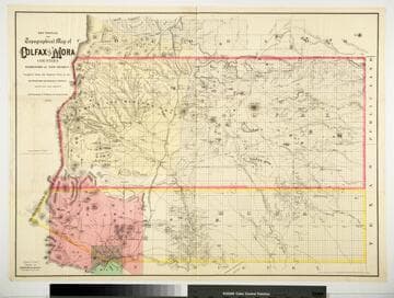
Sectional and Topographical Map of Colfax and Mora Counties Territory of New Mexico
Rare Books
Numerous changes have been made since the earlier map, 128069. "Compiled from the Original Plats in the Surveyor Generals Office Santa Fe, New Mexico. J. S. Taylor U. S. Deputy Surveyor, 1881." "Entered according to Act of Congress in the year 1882 by G.W. & C.B. Colton & Co. in the Office of the Librarian of Congress, at Washington." Prime meridian: GM. Relief: hachures. Graphic Scale: Miles. Projection: Cylindrical. Printing Process: Lithography. Verso Text: HL sticker: 128313.
128313
Image not available
Colton's Map of the States and Territories west of the Mississippi River to the Pacific Ocean showing the Overland Routes, proposed Rail Road Lines &c
Rare Books
Note west Texas is a barren plain where the trail is located by stakes. "Entered according to Act of Congress in the year 1871 by G.W. & C.B. Colton & Co. in the Office of the Librarian of Congress at Washington." Prime meridian: GM, Washington. Relief: hachures. Graphic Scale: Miles. Projection: Polyconic. Printing Process: Lithography.
127662
Image not available
Map of the City of Los Angeles California
Rare Books
See 72395 for original map. "Entered according to Act of Congress in the year 1884 by H. J. Stevenson in the Office of the Librarian of Congress in Washington." MS note: 72395. Prime meridian: GM. Relief: hachures. Graphic Scale: Feet. Projection: Plane. Printing Process: Lithography. Verso Text: MS note: 72395 Stamp: A. O. Adams .
235549
Image not available
Bancroft's official guide map of city and county of San Francisco
Rare Books
Cover burned with part of map consumed as well. "Entered according to Act of Congress in the year 1882, by A. L. Bancroft & Co. in the office of the Librarian of Congress at Washington, D.C. " For other editions, see RB 15238, 26260, 83860, 257194, & 340387. Submap: Bay Area. Prime meridian: GM. Relief: no. Graphic Scale: Miles. Projection: Plane. Printing Process: Lithography
213822
Image not available
Treadwell's new map of the Comstock mines : State of Nevada, 1876
Rare Books
"Entered according to Act of Congress in the year 1876 by J. B. Treadwell, C.E. in the office of the Librarian at Washington D.C." Vignette: Mountain view above. MS note: 149919. Prime meridian: GM. Relief: no. Graphic Scale: Feet. Projection: Plane. Printing Process: Lithography. Other Features: Vignettes.
149919