Rare Books
Colton's Map of the States and Territories west of the Mississippi River to the Pacific Ocean showing the Overland Routes, proposed Rail Road Lines &c
You might also be interested in
Image not available
Colton's Map of the United States of America, The British Provinces, Mexico and the West Indies, Showing the Country from the Atlantic to the Pacific Ocean
Rare Books
Nebraska extends to Oregon and Washington, Utah to the California border, New Mexico covers Arizona, Minnesota extends west through the Dakotas. Submaps: Central America; West Indies; Newfoundland. Vignettes: Numerous Natives, animals, ships. Prime meridian: GM, Washington. Relief: hachures. Graphic Scale: Miles. Projection: Polyconic. Printing Process: Lithography.
273835
Image not available
Colton's new rail road & county map of the United States, the Canadas &c
Rare Books
Alt. title from cover. Submaps: Southern Part of Florida; Map of the United States. Prime meridian: Washington. Relief: hachures. Graphic Scale: Miles. Projection: Polyconic. Printing Process: Lithography.
353762
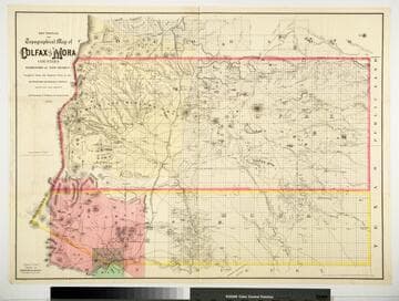
Sectional and Topographical Map of Colfax and Mora Counties Territory of New Mexico
Rare Books
Numerous changes have been made since the earlier map, 128069. "Compiled from the Original Plats in the Surveyor Generals Office Santa Fe, New Mexico. J. S. Taylor U. S. Deputy Surveyor, 1881." "Entered according to Act of Congress in the year 1882 by G.W. & C.B. Colton & Co. in the Office of the Librarian of Congress, at Washington." Prime meridian: GM. Relief: hachures. Graphic Scale: Miles. Projection: Cylindrical. Printing Process: Lithography. Verso Text: HL sticker: 128313.
128313
Image not available
Map of the New York Wilderness and the Adirondacks
Rare Books
"By W. W. Ely, M.D. 1874" "Entered according to Act of Congress in the year 1873 by G.W. & C.B. Colton in the Office of the Librarian of Congress at Washington." Submap: New England and Eastern US.. Prime meridian: Washington. Relief: hachures. Graphic Scale: Miles. Projection: Cylindrical. Printing Process: Lithography. Other Features: Sub-maps.
123304
Image not available
Colton's map of the States and Territories west of the Mississippi River to the Pacific Ocean, showing the overland routes, projected rail road lines &c
Rare Books
Dakota Territory is unsplit, Montana does not exist. Prime meridian: GM. Relief: hachures. Projection: Pseudocylindrical. Printing Process: Lithography. Verso Text: MS note: 298620.
298620
Image not available
Habersham's sectional and countymap of Oregon
Rare Books
"Compiled from the most recent U.S. Government maps & surveys." "Entered according to Act of Congress in the year 1874 by Robert A. Habersham in the Office of the Librarian of Congress at Washington." "Engraved and printed by G.W. & C.B. Colton & Co. New York." Prime meridian: GM. Relief: hachures. Graphic Scale: Miles. Projection: Cylindrical. Printing Process: Lithography.
1545