Rare Books
An Accurate Map of the District of Maine Being Part of the Commonwealth of Massachusetts
You might also be interested in
Image not available
A New and Accurate Map of the British Dominions in America, according to the Treaty of 1763 Divided into the Several Provinces and Jurisdictions. Projected upon the best Authorities and Astronomical Observations by Thos. Kitchin, Geographer
Visual Materials
Kashnor notes, "Shows the coast from the Bay of St. Lewis to Lake d"Ima, New Mexico, and indicates the locations of the various Indian nations. North of the Missouri is a tract marked 'Extensive Meadows full of Buffaloes.' The old boundary lines of the Carolinas and Georgia are still shown reaching the Mississippi." Kashnor dates ca. 1765. McCorkle suggests [1766]. See also 093-432. Prime meridian: London. Relief: pictorial. Graphic Scale: Miles, Leagues. Projection: Pseudocylindrical. Watermark: Crowned fluer-di-lis W. Printing Process: Copper engraving. Other Features: Cartouche. References: McCorkle [766.1]. Verso Text: MS note: 332.
105:332 M

An accurate map of New Hampshire in New England, from a late survey
Visual Materials
Kashnor dates as ca. 1776. Maine is shown as part of New Hampshire. RLIN record gives place of publication, date, and appeared in information as Universal magazine of knowledge and pleasure, March, 1781. MS note: 112 (on backing). Prime meridian: London. Relief: pictorial. Projection: Cylindrical. Watermark: Seal. Printing Process: Copper engraving. References: McCorkle N781.1.
105:112 S
Image not available
New and Accurate Map of Louisiana, with Part of Florida and Canada, and the Adjacent Countries, Drawn from Surveys, assisted by the most approved English & French Maps & Charts. The whole being regulated by Astronl. Observations, by Eman. Bowen
Visual Materials
Kashnor notes, "This shows the boundaires of Louisiana according to the French claims which led to war. It is a good map of the Illinois country, locates Chicago, also of New Mexico, with the location of Santa Fe, Taos, and other towns." Kashnor dates ca. 1745, RLIN record suggests 1745. Cartouche: with Indian.. Prime meridian: London. Relief: pictorial. Graphic Scale: Leagues. Projection: Pseudocylindrical. Watermark: Fluer-di-lis V(?) A G. Printing Process: Copper engraving. Other Features: Cartouche. References: Wheat cv.1, no.122.
093:433 M

This Map of the Province of Nova-Scotia and parts adjacent
Rare Books
Kashnor notes, "Am excessively rare map, one of the few specimens of American map engraving of the eighteenth century. It is dedicated the Edward Cornwallis, Governor of Nova Scotia. There are two small holes in the map, otherwise it is in very fine state with full margins, as issued." Note this differs from the 1776 version in McCorkle (776.27). Cartouche: Pictorial with figures. Vignette: View of Boston Cl.[Colony] of N.E. planned 1630. Sub maps: Situation of Halifax Draught of the Harbour &c.; Plan of Halifax; Plan of Quebec; City & Port of Louisbourg. MS notes: Museum Bk. Store Cat 93 #314, 181666 (on backing). Prime meridian: London. Relief: pictorial. Graphic Scale: Miles. Projection: Cylindrical. Watermark: Crowned device lettering. Printing Process: Copper engraving. Other Features: Cartouche Sub-maps Vignettes. References: McCorkle 776.27. Verso Text: MS note: 181666.
181666
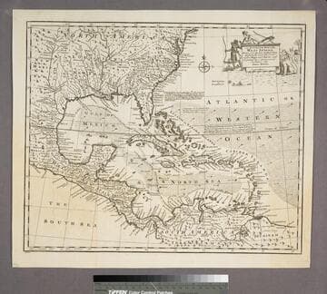
An Accurate Map of the West Indies
Visual Materials
Kashnor notes, "Includes Florida, Georgia, Carolina, Virginia, and Maryland. Also shows the coast of New Leon and present-day Texas." Kashnor dates as ca. 1767. RLIN record suggests 1747. Cartouche: Natives & Lion.. "Drawn from the best Authorities, assisted by the most approved Modern Maps and Charts, and regulated by Astronomical Observations. By Eman. Bowen." Prime meridian: London. Relief: pictorial. Graphic Scale: Miles. Projection: Azimuthal. Printing Process: Copper engraving. Other Features: Cartouche. Verso Text: MS note:943.
105:943 S
Image not available
Bowles's New One-Sheet Map of the United States of America: with the Territories belonging to Great Britain and Spain
Visual Materials
Kashnor notes, "Ohio, Michigan, Illinois, Wisconsin and Minnesota of today were all comprised in the Western Territory, which is shown reaching to the Lake of the Woods, Chicago is located, and the State of Indiana is shown to be about 60 miles long and broad, situated below Ohio." Kashnor dates as ca. 1798. McCorkle dates as 1795. Cartouche: two maidens. . Prime meridian: London, Ferro. Relief: pictorial. Graphic Scale: Miles. Projection: Pseudocylindrical. Printing Process: Copper engraving. Other Features: Cartouche. References: McCorkle 791.1, 768.1(original). Verso Text: MS note: 513.
093:513 M