Rare Books
The Isles of Montreal. as they have been Survey'd By the French Engineers
You might also be interested in
Image not available
Isles of Montreal, as the have been surveyed by the French Engineers
Visual Materials
Kashnor notes, "A scarce plan published about the time of the attack on Montreal during the Old French War." Kashnor dates as ca. 1759. RLIN record suggests ca. 1761. [Old folder notes PD of #150263.] MS note: 93/298 (on backing). Relief: pictorial & hachures. Graphic Scale: Miles. Projection: Plane. Watermark: Crowned GR shield. Printing Process: Copper engraving. Verso Text: MS note: 298 (on backing).
093:298 S

Plan of the City and Environs of New York in North America
Visual Materials
Kashnor dates as circa. 1776. Place and appeared in from RLIN record. Colorful map. MS note: 128 (on backing). Relief: hachures. Graphic Scale: Feet. Projection: Plane. Watermark: Seal Crowned CR lettering. Printing Process: Copper engraving. Other Features: Art Work.
105:128 S

Les Isles Turques d'aprés les Levées de 1753. par le Sloop l'Aigle et l'Emeraude par order du Gouverneur bde St.Dominique corrigées sur les Observations de Ed. Hawke faites en 1770, dans le Shooner Royal
Visual Materials
Kashnor notes, "A scarce map." Prime meridian: London. Relief: hachures. Graphic Scale: Miles. Projection: Plane. Watermark: possible lettering. Printing Process: Copper engraving. Verso Text: MS note: 808.
105:808 S
Image not available
Plan de la Cataracte de Niagara et de l'Isthme que separe les Lacs Erie et Ontario
Rare Books
Mat MS note: 150209. "Ecrit par Giraldon." No. 18. Pl. VI. Tom. II Pag. 131. Prime meridian: GM. Relief: pictorial. Graphic Scale: Miles. Projection: Plane. Watermark: Grapes, lettering. Printing Process: Copper engraving. Verso Text: MS note: 150209.
150209
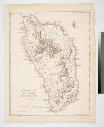
La Dominique située entre la Martinique et la Guadeloupe Conquise par le Mis. de Bouillé Maréchal des Camps et Armées du Roi, le 7 Septembre 1778
Visual Materials
Prime meridian: London, Ferro. Relief: hachures. Graphic Scale: Miles. Projection: Plane. Watermark: Chained maltese cross lettering. Printing Process: Copper engraving. Verso Text: MS note: 763.
093:763 M

Plan of the Town and Citadel of Fort Royal the Capital of Martinico. with the Bay of Cul de Sac Royal. By Mr. de Caylus, Engineer-General of the French Islands
Visual Materials
Submap: Port of Carenage. MS note :819. Relief: hachures. Projection: Plane. Watermark: Crowned fluer-di-lis VI. Printing Process: Copper engraving. Other Features: Sub-maps. Verso Text: Ms note: 819.
093:819 S