Rare Books
West Indies

You might also be interested in
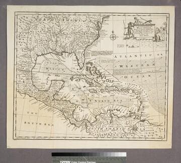
An Accurate Map of the West Indies
Visual Materials
Kashnor notes, "Includes Florida, Georgia, Carolina, Virginia, and Maryland. Also shows the coast of New Leon and present-day Texas." Kashnor dates as ca. 1767. RLIN record suggests 1747. Cartouche: Natives & Lion.. "Drawn from the best Authorities, assisted by the most approved Modern Maps and Charts, and regulated by Astronomical Observations. By Eman. Bowen." Prime meridian: London. Relief: pictorial. Graphic Scale: Miles. Projection: Azimuthal. Printing Process: Copper engraving. Other Features: Cartouche. Verso Text: MS note:943.
105:943 S

West Indies
Visual Materials
Kashnor notes, "Engraving representing sugar being embarked." Kashnor dates as [1760]. Cartouche: Traders & slave MS note: 976 (on backing).. Prime meridian: London. Relief: pictorial. Graphic Scale: Miles. Projection: Conic. Printing Process: Copper engraving. Other Features: Cartouche.
105:976 S

A New Map of the West Indies, For the History of the British Colonies by Bryan Edwards, Esqr
Visual Materials
One map in two sheets. Prime meridian: London. Relief: pictorial. Graphic Scale: Miles. Projection: Conic. Printing Process: Copper engraving. Verso Text: MS note: 967.
105:967 M

A New and Accurate Map of Terra Firma and the Caribbe Islands
Visual Materials
Kashnor dates [circa 1714]. RLIN record suggests publication date as 1747. Cartouche: leaves.. "Drawn from the most approved Modern Maps & Charts, & adjusted by Astron. Observatns. By Eman. Bowen." Prime meridian: London. Relief: pictorial. Graphic Scale: Miles. Projection: Conic. Printing Process: Copper engraving. Other Features: Cartouche. Verso Text: MS note: 959.
105:959 M

Compleat Map of the West Indies, Containing the Coasts of Florida, Louisiana, New Spain, and Terra Firma: with all the Islands. By Samuel Dunn, Mathematician
Visual Materials
Prime meridian: Ferro. Relief: pictorial. Graphic Scale: Miles, leagues. Projection: Conic. Watermark: Fleur-de-lis over GR. Printing Process: Copper engraving. Verso Text: MS notes: 716 West Indies 41.
093:716 M
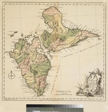
Guadaloupe one of the Caribbee Islands Subject to France in the West Indies, from the Best Authorities By T. Jefferys
Visual Materials
Kashnor dates as [1760]. RLIN record suggests 1768 and provides appeared in information. Cartouche: water falls & plants. Oversize binding spine still attached. Note: mile and league scales do not match.. Prime meridian: Ferro, London. Relief: pictorial & hachures. Graphic Scale: Miles, leagues. Projection: Cylindrical. Watermark: Crowned fleur-de-lis VI. Printing Process: Copper engraving. Other Features: Cartouche. Verso Text: MS notes: 93/775 148 La Guadaloupe La Guadalupe .
093:775 M