Rare Books
Carte d'une Partie de l'Amerique Septentrionale, pour servir a l'Histoire de la derniére Guerre
You might also be interested in
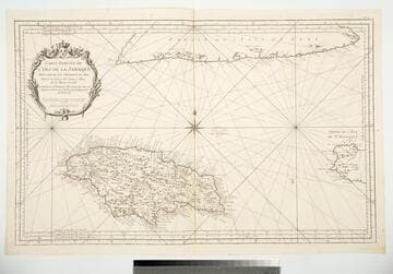
Carte Reduite de l'Isle de la Jamaique Pour servir aux Vaisseaux du Roy Dressée au Dépost des Cartes et Plans de la Marine en 1753
Visual Materials
Cartouche: framed w. flowers and Royal Crest.. Prime meridian: Ferro, Paris, Teneriffe. Relief: pictorial. Graphic Scale: Leagues. Projection: Cylindrical. Watermark: Device lettering. Printing Process: Copper engraving. Other Features: Cartouche. Verso Text: MS note: 790.
093:790 M
Image not available
Carte de l'Amerique Septentrionale
Rare Books
Paper watermark suggests publication date of 1782 or later. Sticker on old folder 984. Cartouche: Royal shield. "Prix. trente Sols. No. 56 (upper right)" "Depuis le 28 Degré de Latitude jusquau 72. Par M. Bellin Ingenieur de la Marine et du Depost des Plans, Censeur Royal, de l'Academie de Marine, et de la Societé Royale de Londres. MDCCLV." Prime meridian: Paris, Ferro. Relief: pictorial. Graphic Scale: Leagues, Miles. Projection: Azimuthal. Watermark: FIN TAMI... 1782, Crowned bird. Printing Process: Copper engraving. Other Features: Cartouche. Verso Text: MS note: 192568.
192568
Image not available
Carte de la Nouvelle France Pour servir a l'Etude de l'Historie du Canada Depuis sa Découverte Jusqu'en 1760
Rare Books
New France extends down to the Ohio River and westward from there. Submaps: Lake Champlain; Montreal; Quebec City; Louisiana; Hudson's Bay. Vignette: Quebec City in 1688.. "Par P. M. A. Genest" "Enregistré conformément a l'Acte du Parliament du Canada en mil huit cent soixante-et-quinze, par P.M.A. Genest, au Bureau de Ministre de l'Agriculture." Prime meridian: Paris. Relief: no. Graphic Scale: Leagues, Miles. Projection: Polyconic. Printing Process: Engraving. Other Features: Sub-mapsVignettes. Verso Text: MS notes: 318 1022.
115003
Image not available
Carte de la Partie Nord, des Etats Unis, dee l'Amerique Septentrionale
Rare Books
Mat MS: 988/4. Prime meridian: Paris, Ferro. Relief: pictorial. Graphic Scale: Miles. Projection: Conic. Watermark: Lettering. Printing Process: Copper engraving. References: Philips Atlases, 652, no. 47. Verso Text: 17 150092.
150092
Image not available
Carte Nouvelle de l'Amerique Angloise
Rare Books
A colorful map showing the colonies limited east of the Appalachians. Pittsburgh is shown as Fort du Quesne in French territory. Appeared in Tobias Conrad Lotter's Atlas geographique, 1778. Cartouche: crowned with cost of arms. MS note: 111315. Prime meridian: [Ferro]. Relief: pictorial. Graphic Scale: Leagues. Projection: Pseudocylindrical. Watermark: Device with partial cross. Printing Process: Copper engraving. Other Features: Cartouche. Verso Text: MS note: Englisches Amerika.
111315
Image not available
Carte de l'Amerique Septentrionale
Visual Materials
Kashnor notes, "Shows California with coast reaching to the Strait of Martin d'Aquilar. locating Nle. Albion; also shows a good map of New Mexico." Kashnor dates ca. 1750. RLIN record suggests 1766. Prime meridian: Ferro. Relief: no. Graphic Scale: Leagues. Projection: Pseudocylindrical. Watermark: Chained Maltese cross. Printing Process: Copper engraving. Other Features: Cartouche. Verso Text: MS note: 216.
105:216 S