Opening Hours
Daily: 10 A.M.–5 P.M.
Closed on Tuesdays
1151 Oxford Road
San Marino, CA 91108
Rare Books
Daily: 10 A.M.–5 P.M.
Closed on Tuesdays
1151 Oxford Road
San Marino, CA 91108
Image not available
Rare Books
See also Museum Bookstore map 105:478, described as follows: Kashnor notes, "Shows the course of the Missouri extending north of the Rockies, where the Spaniards forded the river to trade with the people for yellow iron, "du fer jaune." Also shows Carolina, Virginia, Maryland, and New Mexico." Kashnor dates as ca. 1720. This edition shows New Orleans. Sub map of the Mississippi delta. See 093:550M for an earlier version and 52352 for a reproduction. Sub map: Carte Particuliere des Embouchures de la Riviere S. Louis et de la Mobile. "Dresée sur un grand nombre de Memoires entr autres sur ceux de Mr. le Maire Par Guillme. de l'Isle de l'Academie Rle. des Sciences." Prime meridian: Ferro. Relief: pictorial. Graphic Scale: Leagues. Projection: Cylindrical. Printing Process: Copper engraving. Verso Text: MS notes: 150047 La Louisiane & Cours du Mississipi.
150047

Visual Materials
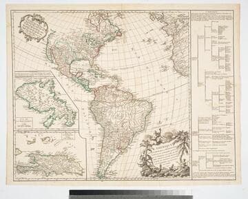
Kashnor notes, "In this the coast of California only extends as far as Cape Blanc, and New Albion, Monterey and Cape Mendocin are located." See 093:158 for a later version of this map. Two submaps. Note map on verso. Kashnor states published in Paris. Two submaps; Isle de la Martinique; Isle de S. Domingue. Also table listing the various subdivisions of the continents.. Prime meridian: Ferro. Relief: pictorial. Graphic Scale: Miles, leagues. Projection: Pseudocylindrical. Printing Process: Copper engraving. Other Features: Sub-mapsCartouche. Verso Text: MS notes: Havana map 164a. (pasted to verso).
093:164 M

Visual Materials
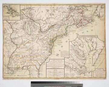
Proposed peace settlement lines shown. Submaps of Florida and Caribbean Islands, second submap of Chesapeake Bay area labeled: Suplément Qui represente la partie de la Virginie ou se trouvent le Theatre ou l'Armée Combinée des Francois et des Etats Unies a fait prisonnier le Geeneral Cornwalis Le 19 Octobre 1781 et le Plan d'attaque d'Yorck et de Glocester Par les Generaux Washington et Rochambeau. Le detail de la Baye de Chesapeake, par L. Denis... Many notes of battles fought during Revolutionary War. Submaps of Caribbean and Florida, Chesapeake Bay.. Prime meridian: Ferro. Relief: pictorial. Graphic Scale: Italian miles, Grand leagues, Common leagues, Journeys of Savages.. Projection: Pseudocylindrical. Watermark: Chain enclosed Maltese Cross. Printing Process: Copper engraving. Other Features: Sub-maps. References: McCorkle 783.18. Verso Text: MS note: 85.
093:085 M
Image not available
Visual Materials
Kashnor notes, "Shows the course of the Missouri extending north of the Rockies, where the Spaniards forded the river to trade with the people for yellow iron, "du fer jaune." Also shows Carolina, Virginia, Maryland, and New Mexico." This edition does not show New Orleans. Submap of the Mississippi delta. Appeared in information from RLIN record. See 105:478M for a later version and RB 52352 for a reproduction. Submap: Carte Particuliere des Embouchures de la Riviere S. Louis et de la Mobile. Prime meridian: Ferro. Relief: pictorial. Graphic Scale: Leagues. Projection: Cylindrical. Printing Process: Copper engraving. Verso Text: MS note: 550.
093:550 M
Image not available
Rare Books
The memoirs of Louis Antoine Fauvelet de Bourrienne, a French diplomat who had a close friendship with Napoleon Bonaparte; describes in detail Napoleon's various relationships, including with his mother, his first wife Joséphine de Beauharnais, various politicians, and more.
644858
Image not available
Visual Materials
Kashnor notes, "Shows the course of the Missouri extending north of the Rockies, where the Spaniards forded the river to trade with the people for yellow iron, "du fer jaune." Also shows Carolina, Virginia, Maryland, and New Mexico." Kashnor dates as ca. 1720. This edition shows New Orleans. Submap of the Mississippi delta. MS note: 41 (upper right). Appeared in information from RLIN record. See 093:550M for an earlier version, 150047 for the same version, and 52352 for a reproduction. Submap: Carte Particuliere des Embouchures de la Riviere S. Louis et de la Mobile. Prime meridian: Ferro. Relief: pictorial. Graphic Scale: Leagues. Projection: Cylindrical. Printing Process: Copper engraving. Verso Text: MS note: 478.
105:478 M