Rare Books
Road Map of the Island of Rhode Island, or Aquidneck
You might also be interested in

New & Accurate Map of the Island of Jamaica Divided into its Parishes, Containing theTowns, Plantations, Forts, Capes, Bays, &c. from all the Surveys made there of the Year 1755
Visual Materials
Two submaps. Submap: The Harbour of Port-Royal; Particular Plan of Port Royal before the Earthquake in 1692 and after the present year of 1755. . Prime meridian: London. Relief: pictorial. Graphic Scale: Miles. Projection: Cylindrical. Printing Process: Copper engraving. Other Features: Sub-maps.
093:800 M
Image not available
Map of the City of Los Angeles : showing the confirmed limits surveyed in August, 1857 / by Henry Hancock
Rare Books
A famous cornerstone map of Los Angeles incorporating Ord's survey but extending the City to show many property owners. "Plan de la Ciudad de Los Angeles surveyed by E.O.C. Ord, Lt. USA and Wm. R. Hutton, Assistant." "Donation Lots Surveyed by H. Hancock in August and April 1853. George Hanson, Asst." "A. L. Bancroft Co. Lith." Prime meridian: GM. Relief: hachures. Graphic Scale: Miles. Projection: Plane. Printing Process: Lithography.
219105
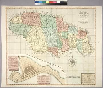
Bowles's New One-Sheet Map of Jamaica, Divided into its Parishes, &c. from the Actual Surveys of Sheffield and others
Visual Materials
Submap: General plan of Port Royal [showing before and after earthquake dimensions].. Prime meridian: London. Relief: pictorial. Graphic Scale: Miles. Projection: Cylindrical. Printing Process: Copper engraving. Other Features: Sub-maps. Verso Text: MS note: 788.
093:788 M
Image not available
Plan of the Central Tract.; Pasadena, Cal
Rare Books
California Street (now Blvd.) on the north, Fair Oaks on the west, Marengo on the east, San Pasqual appears to be current Pico Street, Central Street appears to be current Fillmore St. verso has submap and sales information. "Being a Subdivision of Lots 1, 3 and 4 of Block N, of the San Pasqual Tract" "Surveyed by Williell Thomson, November, 1884. Recorded in Book 6 of Miscellaneous, Page 121, Records of Los Angeles County. Chas. E. Miles, County Recorder." Relief: no. Graphic Scale: Feet. Projection: Plane. Printing Process: Lithography. Verso Text: Submap: Plan showing Position of the Central Tract, Pasadena. Sales description of the tract..
449173
Image not available
A New Chart of the Coast of Nova Scotia with the South Coast of New Brunswick; including also part of the Islands of St. John and Cape Breton, and of the Coast of New England : Regulated and Ascertained by Astronomical Observations by. Capt. Holland
Visual Materials
Note that date on map has been inked over and that this is a second edition, probably later. Contains submaps. Kershaw notes this as third state, supplies appeared in information. Submaps: Plan of River St. John; Plan of Port Roseway Harbour; Plan of the Entrance of Harbour of River of St. John. Views: Lighthouse Island; Chebucto Head; Cape Spry.. Prime meridian: London. Relief: hachures. Graphic Scale: Leagues. Projection: Cylindrical. Printing Process: Copper engraving. Other Features: VignettesSub-maps. References: Kershaw 806; L C Phillips 1236, 4476. Verso Text: MS note: 612.
105:612 M
Image not available
Ensign, Bridgman & Fanning's Rail Road Map of the United States, showing the Depots & Stations
Rare Books
Alt. title from cover. Submap: Plan of the New England States. Prime meridian: Washington. Relief: hachures. Graphic Scale: Miles. Projection: Polyconic. Printing Process: Lithography. Verso Text: MS note: Map Ensiign, Bridgman & F.
340653