Rare Books
Special Map Illustrating the Spanish-American War
You might also be interested in
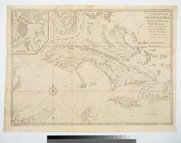
A New & Correct Chart of Cuba, Streights of Bahama, Windward Passage, the Current through the Gulf of Florida, with the Soundings &c. By an Officer in the Navy
Visual Materials
Kashnor dates as ca. 1740. Sub-map: A Plan of the Harbour & Town of Havana. Prime meridian: London. Relief: pictorial. Projection: Mercator. Printing Process: Copper engraving. Other Features: Sub-maps. Verso Text: MS note: 381.
105:381 M
Image not available
Scientific American Navy Supplement Map of Cuba
Rare Books
Submaps: Havana; Puerto Rico; Caribbean. "Navy Edition of the Scientific American Supplement., No. 1165." Prime meridian: GM, Washington. Relief: hachures. Graphic Scale: Miles. Projection: Pseudocylindrical. Printing Process: Lithography. Other Features: Sub-maps. Verso Text: Ms note: 150268.
150268
Image not available
A Map of North America, constructed according to the latest information
Rare Books
A large detailed map with notes carefully explaining the possible inaccuracies of western rivers, etc. Sub map: Western Part of Alleutian Islands. Cartouche: Incorporating views of Natural Bridge in Virginia and Niagara Falls. Vignette: Comparison of altitudes of mountains and towns in North America. "By H. S. Tanner" "Printed by Wm. Duffee." Prime meridian: Washington. Relief: hachures. Graphic Scale: Miles. Projection: Mercator. Printing Process: Lithography. Other Features: Sub-maps Cartouche Vignettes.
121198

New & Accurate Map of the Seat of the late War in the West Indies with a plan of the City and Harbour of Havannah. 1763
Visual Materials
Submap: Havana Harbor. MS note: 757 (on backing). Prime meridian: Ferro. Relief: pictorial. Projection: Cylindrical. Printing Process: Copper engraving. Other Features: Sub-maps. Verso Text: MS note: 757 (on backing).
093:757 S
Image not available
War maps, views and portraits
Rare Books
At head of title: "Harper's Weekly Journal of Civilization." A bird's-eye view of Chesapeake Bay surrounded by eight maps of areas involved in the Civil War. Seven vignettes, four portraits of Northern Military leaders. Submaps: Map of the Seat of the War in the West; Map of the coastline from the mouths of the Mississippi River to Pensacola; Map of the Battle of Bull Run; Map of the Seat of the War in Virginia; Comparative area of Northern and Southern States 1861; Map of Charleston Harbor; Map of Pensacola Harbor; Map of strategic routes; Balloon view of Fort Monroe and the mouth of the Chesapeake. Vignettes: Seven vignettes and four portraits. Relief: hachures. Projection: Birds-eye view. Printing Process: Lithography. Verso Text: MS notes: 49861 Maps... 1861.
49861
Image not available
Spanish American War
Manuscripts
Linen-backed map of Philippine campaigns during the Spanish American War. "Color Photos of America's New Possessions" - bound book of color images of the Philippines and the Spanish American war. Published in 1899
mssLAT