Visual Materials
New & Accurate Map of the Seat of the late War in the West Indies with a plan of the City and Harbour of Havannah. 1763

You might also be interested in
Image not available
Accurate Map of the British Empire in Nth. America as settled by the Preliminaries in 1762
Visual Materials
Contains submap of Mississippi delta. Submap: Chart of the Entrance of the Mississippi. MS note: 277 (on backing). Prime meridian: London, Ferro. Relief: pictorial. Graphic Scale: Miles. Projection: Cylindrical. Printing Process: Copper engraving. Other Features: Sub-maps. Verso Text: MS note: 277 (on backing).
093:277 S
Image not available
New and Accurate Plan of the River St. Lawrence, from the Falls of Montmorenci to Sillery, with the Operations of the Siege of Quebec 1763
Visual Materials
This map appears to be a reduced size copy of Jefferys' map, 093:325 and 093:325A. The engraving is less detailed. Submap of Sep. 13 1759. MS note: 329A (on backing). Relief: hachures. Graphic Scale: Miles. Projection: Plane. Printing Process: Copper engraving. Other Features: Sub-maps. Verso Text: MS note: 329A (on backing).
093:329A S

A new and accurate map of the present seat of war in North America, from a late survey
Visual Materials
Kashnor notes, "A scarce map, issued during the early part of the Revolution." Kashnor dates c.1776. RLIN record places publication in London and appearance in Universal Magazine. MS note: 107 (on backing). Prime meridian: Ferro. Relief: pictorial. Graphic Scale: Miles. Projection: Cylindrical. Watermark: Two seals. Printing Process: Copper engraving.
105:107 S
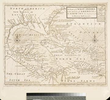
Chart of the West Indies or the Islands of America in the North Sea &c. Being the Present Seat of War. by Herman Moll Geographer
Visual Materials
Kashnor notes, "Shows the mainland around the Gulf of Mexico, with Louisiana, Florida, Georgia, and Carolina." Kashnor dates as ca. 1719. Submap: Vera Cruz harbor. Sailing instructions for galleons. MS note: 321 (on backing). Prime meridian: London. Relief: no. Projection: Cylindrical. Watermark: Two devices. Printing Process: Copper engraving. Other Features: Sub-maps.
105:321 S

The British Governments in Nth. America Laid down agreeable to the Proclamation of Octr. 7, 1763
Visual Materials
Kashnor notes, "Giving the whole of N. America from James's Bay to Florida, and west to Louisiana." Inset map of Bermuda. Submap of Bermuda or Summer Islands. MS note: 131 Dec. 1763(p.577) (on backing). Prime meridian: Ferro. Relief: pictorial. Projection: Pseudocylindrical. Printing Process: Copper engraving. Other Features: Sub-maps. Verso Text: Ms note: 131 (on backing).
093:131 S
![Chart of the West-Indies or the Islands of America in the North Sea &c. [Being the Present Seat of War] (probably added by Bowles) by Herman Moll Geographer](/_next/image?url=https%3A%2F%2Frail.huntington.org%2FIIIF3%2FImage%2F22APN4KV8V8V%2Ffull%2F%5E360%2C%2F0%2Fdefault.jpg&w=750&q=75)
Chart of the West-Indies or the Islands of America in the North Sea &c. [Being the Present Seat of War] (probably added by Bowles) by Herman Moll Geographer
Visual Materials
Kashnor notes, "A re-issue of Moll's map at the time of Vernon's expedition. Bowles appears to have secured possession of all of Moll's plates." Kashnor dates as ca. 1740. MS notes: 714 (upper left and on backing). Submap: La Vera Cruz.. Prime meridian: London. Relief: no. Projection: Cylindrical. Printing Process: Copper engraving. Other Features: Sub-maps.
093:714 S