Rare Books
Map of the City of South Pasadena
You might also be interested in

Oneonta Park and South Pasadena
Visual Materials
Oneonta Station at Fair Oaks and Huntington Drive with Raymond Hotel in the background.
photCL Pierce 05948
Image not available
Map of Oneonta Park being Huntington Land and Improvement Co's. subdivision
Visual Materials
Old shelf number: eph J3-5 (So. Pas. 2a). The area just north of Huntington Drive and around Fair Oaks Avenue. Note "Fair Oaks Avenue" is now Fremont Avenue, "Palermo Avenue" is now Fair Oaks Avenue. Stamps for "sold" lots. For another version of this map, which does not list R.A. Rowan as an agent, see RB ephMPCALIFT0013. For a map of Oneonta Park and its surroundings in the 1920s, see RB ephMPCALIFT0014. Prime meridian: GM. Relief: no. Graphic Scale: Feet. Projection: Plane. Printing Process: Lithography.
ephMPCALIFT0013a
Image not available
Map of Oneonta Park being Huntington Land and Improvement Co's. subdivision
Visual Materials
Old shelf number: eph J3-5 (So. Pas. 2a). The area just north of Huntington Drive and around Fair Oaks Avenue. Note "Fair Oaks Avenue" is now Fremont Avenue, "Palermo Avenue" is now Fair Oaks Avenue. MS notes regarding prices and noting "Aug. 10, 1909." For another version of this map, which lists R.A. Rowan as an additional agent, see RB ephMPCALIFT0013. For a map of Oneonta Park and its surroundings in the 1920s, see RB ephMPCALIFT0014. Prime meridian: GM. Relief: no. Graphic Scale: Feet. Projection: Plane. Printing Process: Lithography.
ephMPCALIFT0013
Image not available
B. O. Kendall's Map of the City of Pasadena, Cal. Corrected to August 1st, 1895
Rare Books
Arroyo Drive on the west, Hill Avenue of the east, Columbia Street on the south, Montana St. on the north. Includes street directory. MS notes show added corrections to Sept. 1902]. MS note: Red Line. Relief: no. Projection: Plane. Printing Process: Lithography. Verso Text: Partial cover includes ad for Union Photo Engraving co..
381667
Image not available
H. N. Rust & Son's Palm Place Nursery. South Pasadena, Cal
Rare Books
Title reflects usage of one portion of this map. Monterey Road on the north, Bank Street on the south, Fair Oaks Avenue on the east, Diamond Avenue on the west. Residences of D. M. Graham and Jewett shown. This map is a subdivision map of this area, see also 246144, a wider view. MS notes: lot information.. Relief: no. Graphic Scale: Feet. Projection: Plane. Printing Process: Lithography. Verso Text: MS note: 246145.
246145
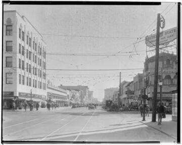
East Colorado looking east, Pasadena. 1930
Visual Materials
View of East Colorado facing east from Fair Oaks Avenue. Businesses shown include Liggett's Drug Store, Good Fellows Grill, and United Cigar. A complicated web of cables for the streetcars is overhead. Automobiles are parked and moving on the streets.
photCL 402 (32601)