Visual Materials
A New Map of the Caribbee Islands in America 1761

You might also be interested in
Image not available
A map of the country round Philadelphia : including part of New Jersey New York Staten Island & Long Island
Visual Materials
Kashnor dates as ca. 1760. Jolly identifies as from Gentleman's Magazine, of Sept. 1776 [as does printing transfer on verso]. MS note: 729 (on backing). Prime meridian: London. Relief: pictorial. Graphic Scale: Miles. Projection: Cylindrical. Printing Process: Copper engraving. References: Jolly, Brit. Periodicals Gent-247. Verso Text: Text transfer.
105:729 S

Island of St. Domingo. Engrav'd for Luffman's Select Plans
Visual Materials
Kashnor notes, " Indicates the old French and Spanish division, the latter nominaly ceded to France by the Treaty of 1795; but, in reality, the country was already in the hands of the negroes." MS note: 419 (on backing). Prime meridian: London. Relief: pictorial. Graphic Scale: Miles. Projection: Cylindrical. Printing Process: Copper engraving.
105:419 S

Map of the Country round Philadelphia including part of New Jersey New York Staten Island & Long Island
Visual Materials
Kashnor notes, "a scarce war map." MS note: 121 (on backing). Prime meridian: London. Relief: pictorial. Graphic Scale: Miles, British Statute. Projection: Cylindrical. Watermark: Crowned seal. Printing Process: Copper engraving. Verso Text: MS note: 121 (on backing).
093:121 S

A new and accurate map of the present seat of war in North America, from a late survey
Visual Materials
Kashnor notes, "A scarce map, issued during the early part of the Revolution." Kashnor dates c.1776. RLIN record places publication in London and appearance in Universal Magazine. MS note: 107 (on backing). Prime meridian: Ferro. Relief: pictorial. Graphic Scale: Miles. Projection: Cylindrical. Watermark: Two seals. Printing Process: Copper engraving.
105:107 S
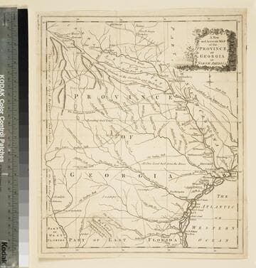
A new and accurate map of the province of Georgia in North America
Visual Materials
Kashnor notes," An old map published about 1775, shewing the roads and Indian paths." Kashnor dates c.1775. Duplicate map to 093:094S, 093:391. RLIN record notes date as [1779?] and place of publication as [London?] and as appearing in The Universal Magazine of 1779. MS note: 103 (on backing). Prime meridian: [Ferro]. Relief: pictorial. Projection: Cylindrical. Watermark: Crowned circular seal. Printing Process: Copper engraving.
105:103 S

The West Indies, Exhibiting the English French Spanish Dutch & Danish Settlements with the Adjacent Parts of North & South America, from the best Authorities
Visual Materials
Kashnor notes, "Showing the settlements of the Caribbee Islands effected by the Treaty of 1783." Kashnor dates as ca. 1790. This may be a reduced size version of I. Prockter's 1762 map. MS note: 975 (on backing). Prime meridian: Ferro. Relief: pictorial. Projection: Cylindrical. Printing Process: Copper engraving.
105:975 S