Visual Materials
A Map of Virgina according to Captain John Smiths Map Published Anno 1606 Also of the Adjacent Country called by the Dutch Niew Nederlant Anno 1630 By John Senex 1735
You might also be interested in
Image not available
Map of Louisiana and of the River Mississipi by John Senex
Visual Materials
Kashnor notes, "The best of the early English maps, giving particulars of the West. The Mississippi is given with all its tributaries, the Red, Arkansas and Missouri Rivers, the last-named being shown with remarkable correctness, its course reaching to the north of the Rockies, where it is stated that the Spaniards ford the river to trade with the people to the North-West for "yellow iron." The map shows New Mexico, and locates Santa Fe." Kashnor dates as [1719]. New Orleans does not appear, same as on l'Isle map of same year. See 148964 for another copy, 093:429 for an apparently later copy. Cartouche: Around dedication. Prime meridian: London. Relief: pictorial. Graphic Scale: Leagues. Projection: Cylindrical. Watermark: Small fleur-di-lis. Printing Process: Copper engraving. Other Features: Cartouche. Verso Text: MS note: 558.
093:558 M
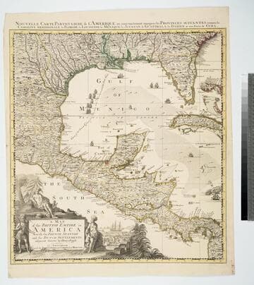
Map of the British Empire in America With the French, Spanish and the Dutch Settlements adjacent thereto by Henry Popple
Visual Materials
Kashnor notes, "Copied from Popple's map With the titles in English and French. ShoWs Carolina divided into counites, With Georgia and the Forts neWly erected, and Savannah." Kashnor dates as ca. 1740, RLIN record suggests 1755. Cartouche of Indians, traders. MS note: No. 10. Relief: pictorial. Projection: Cylindrical. Printing Process: Copper engraving. Other Features: Cartouche. References: McCorkle [741.2]. Verso Text: MS note: 326.
105:326 M
Image not available
[A Map of Pennsylvania / by Reading Howell]
Visual Materials
Kashnor notes, "The first issue of Howell's map printed in America. It is exceedingly rare." Title from State 2, RB # 093:572. Prime meridian: Philadelphia. Relief: hachures. "To the Legislature and the Governor of Pennsylvania This Map is respectfully Inscribed by Reading Howell." "J. Trenchard Sculp." Graphic Scale: Miles. Projection: Cylindrical. Watermark: J. Honig & Zoonen Fleur-di-lis over J. H & Z. Printing Process: Copper engraving. Verso Text: MS notes: 725/Mus Cat. #105 39
105:725 M
Image not available
A New Map of the English Empire in America viz Virginia, New York [etc.]. Revised by Jon Senex, 1719
Visual Materials
Kashnor notes, "a rare and important map." This is the second & last state of the Morden map, see 105:541M, only the cartouche is changed. Cartouche surmounted by dedication. Submaps: The Harbour of Boston or Massachusetts Bay; A General map of the Coasts and Isles of Europe, Africa, and America. "I. Harris sculp: Dedication: Most humbly Inscrib'd ti Herver Edgly Herver of Clapham Esq. &c." Prime meridian: London. Relief: pictorial. Graphic Scale: Miles. Projection: Pseudocylindrical. Watermark: Fleur-di-lis. Printing Process: Copper engraving. Other Features: Sub-mapsCartouche. References: Tooley (Amer) p.63, #20. Verso Text: MS note: 542.
105:542 M
Image not available
A Map of Louisiana and of the River Mississipi by John Senex
Rare Books
Kashnor notes,"This is taken from Delisle's map. In the far north-west is engraved the Missouri passing north of the Rockies, with the inscription, 'The Indians say that near this place the Spaniards ford the river on Horse-back, going to treat with some nations lying to the northwest, whence they bring Yellow Iron, as they call it.' This gold came from California or Cariboo. A century afterwards Lewis and Clark followed the river until they could stand astride of it." Kashnor dates as [1719]. New Orleans does not appear, same as on l'Isle map of same year. See 093:558M for another copy and 093:429 for an apparently later copy. Cartouche: Around dedication. "This Map of the Mississipi is Most Humbly Inscribed to William Law of Lanreston Esq." Prime meridian: London. Relief: pictorial. Graphic Scale: Leagues. Projection: Cylindrical. Watermark: Small fleur-de-lis HD. Printing Process: Copper engraving. Other Features: Cartouche. Verso Text: MS note:703/105 025.
148964
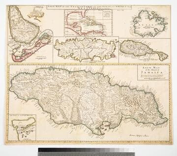
Map of the English Empire in the Ocean of America or West Indies, revised by J. Senex; A New Map of the Island of Jamaica; Barbados & Bermuda; Tobago; Antego; St. Christophers; Harbour at Port Royall
Visual Materials
Kashnor notes," The map of Bermuda locates all the tribes." This map is eight maps on one sheet. See 105:192 for earlier version of this map. Eight maps on one sheet. MS notes: 10 Sen 0 Savanna, signifies a Plain . Relief: pictorial. Graphic Scale: varies. Projection: Plane. Printing Process: Copper engraving. Other Features: Sub-maps. Verso Text: MS note: 191.
105:191 M