Manuscripts
Map of 2 tracts of land.; West bank of the River San Gabriel

You might also be interested in
Rancho San Pedro : S35 no. 2 - sketch map
Manuscripts
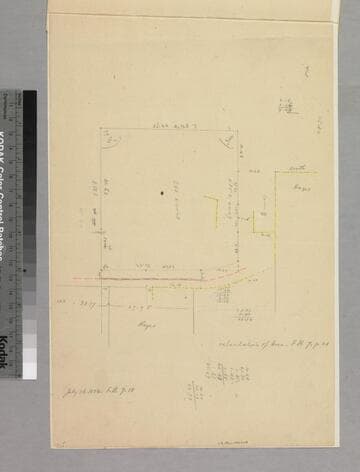
P. 13 of document: "Rancho San Pedro, Manuel Dominguez, Dominguez Heirs partition 1884/85... Dominguez Colony" showing courses, distances; minor color highlighting, parcel owners; acreage. Title supplied by cataloger.
mssSolano SR_Box_24(01).09

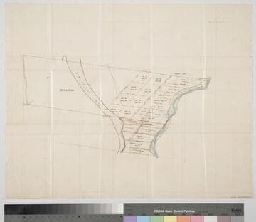
Map of 10 acre tract in.; owned by M. Higuera
Manuscripts
Bordered by Rancho La Ballona. Color highlighting, acreage, courses, distances, structures, surface detailing. Alt. title supplied by cataloger.
mssSolano SR_Box_23(04).01

Map of Hellman Tract, San Pedro Ranch
Manuscripts
Bordered by Temple & Gibson, Manuel Dominguez tracts. Surveyed & subdivided in January 1871 at the request . . . of I. W. Hellman, Esq. Surface detail and parcel owners; color highlights, hachures, structures, waterways. Copied by L. C. Wright.
mssSolano SR_Map_0204.01

Map of that part of the Rancho San Pedro allotted to Manuel Dominguez
Manuscripts
Bordered by Pacific Ocean, Rancho Los Cerritos, Sausal Redondo. Showing parcel owners: heirs of Maria Engracia Cota de Dominguez. Surface detail: hachures, water bodies, vegetation, subdivisions; color highlighting. Numerous tables with partitioned tract data, courses, distances, owners; table of allotments, Inner Bay, Salt Flat, Rattlesnake Island courses, distances. Signed by witnesses.
mssSolano SR_Map_0797
Rancho San Antonio : S65 - subdivision map, land between Los Angeles and Old San Gabriel rivers
Manuscripts
With color highlighting, surface details; courses, distances, showing parcel numbers and acreage, parcel owners. Title supplied by cataloger.
mssSolano SR_Box_23(06).03

Map showing the Puente Road (blue lines)
Manuscripts
Part of bound deed: "Ro. La Puente, Sentous Bros., William Workman & Peregriuse Fitzhugh to E.F. Beale & Robert S. Baker..." Color highlighting, courses, distances, acreage, parcel owners, minor surface detail. Alt. title supplied by cataloger.
mssSolano SR_Box_23(01).02