Manuscripts
Map showing the Puente Road (blue lines)

You might also be interested in

Rancho San Antonio : S65 - large tissue parcel map
Manuscripts
With color highlighting; shows parcels owners, acreage, distances; minor surface detail, railroad. Title supplied by cataloger.
mssSolano SR_Box_23(06).10
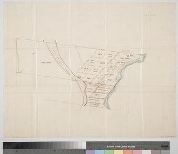
Rancho San Antonio : S65 - subdivision map, land between Los Angeles and Old San Gabriel rivers
Manuscripts
With color highlighting, surface details; courses, distances, showing parcel numbers and acreage, parcel owners. Title supplied by cataloger.
mssSolano SR_Box_23(06).03

Plat of the Santa Anita Rancho finally confirmed to Henry Dalton
Manuscripts
Sierra Madre or San Gabriel Mtns Color highlighting ; featuring parcel owners, township & section numbers, stations, courses, distances, acreage, with two tables of boundary data ; minor surface detail. Alt. title supplied by cataloger.
mssSolano SR_Box_25(06).01

Rancho la Puente : S41 (Goodwin et al vs Rowland) - map of partition
Manuscripts
Bordered by Ranchos La Habra, Cajon de San Juan, Rincon de la Brea. This and the rest of the maps are bound in folder: "Goodwin et al vs. Rowland, Survey of Rancho la Puente..." this map between pages 1 & 2 - showing courses, distances, parcel owners, acreage, surface details (La Puente Hills), markers, waterways. Title supplied by cataloger.
mssSolano SR_Box_22(13).02

Rancho Rincón de los Bueyes : S60 - Antonio José Rocha parcel
Manuscripts
Bound within document, "Louis Stenous & Bros." p. 7, with color highlighting, parcel owners; acreage, courses, distances; road, creek. Title supplied by cataloger.
mssSolano SR_Box_23(04).02

Map of Compton and Cerritos Road (Map. No. 13)
Manuscripts
Original survey 8/1878 by John E. Jackson; within document: 1884-1885 Ro. San Pedro Roads, Road from Compton..." 4th page in; color highlighting, showing courses, distances, surface details; Temple, Hellman, Manuel Dominguez tracts; RR tract, waterbodies, Dominguez house, lot numbers. Copied by Alfred Solano. Alt. title supplied by cataloger.
mssSolano SR_Box_23(15).08