Manuscripts
Map of a Tract of land surveyed.; at the request of George Crosson

You might also be interested in
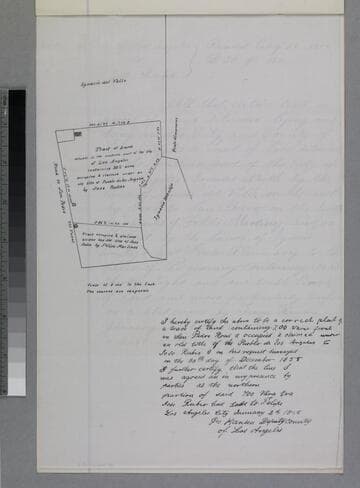
Tract of Land
Manuscripts
P. 3 of fastened document, "Rubio Tract," showing structures, courses, distances, structures, adjacent parcel owners. Alt title supplied by cataloger.
mssSolano SR_Box_31(40).01
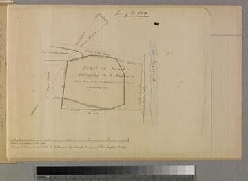
Tract of land belonging to L Wilhard
Manuscripts
P. 4 of fastened document, "Luis Wilhart Tract," Survey No. 104: west of Los Angeles River, showing courses, distances, acreage, Road to Toma, adjacent parcel owners [see also Map folder 305]. Alt title supplied by cataloger.
mssSolano SR_Box_33(13).01
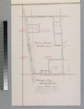
Map of the land belonging to George Palmer in the Temple & Gibson Tract
Manuscripts
P. 12 of stapled document, "George Palmer... Deed..." courses, distances, acreage, parcel owners; S.P.R.R.. Alt title supplied by cataloger.
mssSolano SR_Box_31(01).03

Map of a Survey of the John D. Young Tract
Manuscripts
Original survey by E.T. Wright, Nov. 1875. ; Copied by Alfred Solano. Shows parcel numbers, acreage, courses, distances; hachures. Alt. title supplied by cataloger.
mssSolano SR_Box_20(06).01

Wilhart (Luis) Tract : tract of land belonging to L Wilhard copy of previous map
Manuscripts
P. 5 of fastened document, "Luis Wilhart Tract," Survey No. 104: west of Los Angeles River, showing courses, distances, acreage, Road to Toma, adjacent parcel owners. Title supplied by cataloger.
mssSolano SR_Box_33(13).02

Map of the Keller Tract
Manuscripts
...in the North East quarter of Sec. 16, T.2 S.R.13 W. S.B.M., South Ave. to Alameda St. from Vernon Ave. to Rubio St., showing parcel owners, color highlighting, courses, distances, acreage; pencil calculations. Paper watermark: Royal Linen Ledger. Alt title supplied by cataloger.
mssSolano SR_Map_0690