Manuscripts
Tract of land belonging to L Wilhard

You might also be interested in

Wilhart (Luis) Tract : tract of land belonging to L Wilhard copy of previous map
Manuscripts
P. 5 of fastened document, "Luis Wilhart Tract," Survey No. 104: west of Los Angeles River, showing courses, distances, acreage, Road to Toma, adjacent parcel owners. Title supplied by cataloger.
mssSolano SR_Box_33(13).02

Wilhart (Luis) Tract : parcel of Mrs. Soledad P. de Willhart
Manuscripts
P. 8 of fastened document, "Luis Wilhart Tract," original survey Feb 6, 1882; showing courses, distances, acreage, Chavez Street; parcel west of Los Angeles River, along Downey Avenue; calculations, stakes & markers. Copied by Alfred Solano.. Title supplied by cataloger.
mssSolano SR_Box_33(13).04
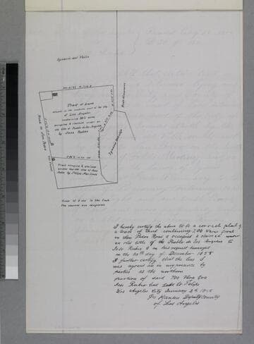
Tract of Land
Manuscripts
P. 3 of fastened document, "Rubio Tract," showing structures, courses, distances, structures, adjacent parcel owners. Alt title supplied by cataloger.
mssSolano SR_Box_31(40).01
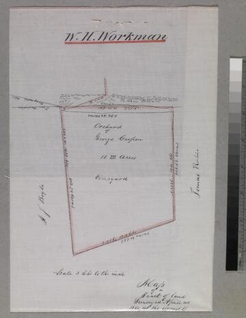
Map of a Tract of land surveyed.; at the request of George Crosson
Manuscripts
Orchard of George Crosson: vineyard, with courses, distances, acreage. Adjacent parcel owners: A. (Andrew) J. Boyle, Tomas Rubio. Copy by Alfred Solano. Alt title supplied by cataloger.
mssSolano SR_Box_33(24).01

Plot of a tract of land belonging to Francisco Ruiz (José Lopez)
Manuscripts
P. 3 [4] of fastened document, "Lorenzo v.d. Leck, April 30, 1879..." survey no. 13 - original map dated April 12, 1854; showing courses, distances, acreage, parcel owners. Copied by Alfred Solano.. Alt. title supplied by cataloger.
mssSolano SR_Box_29(24).01
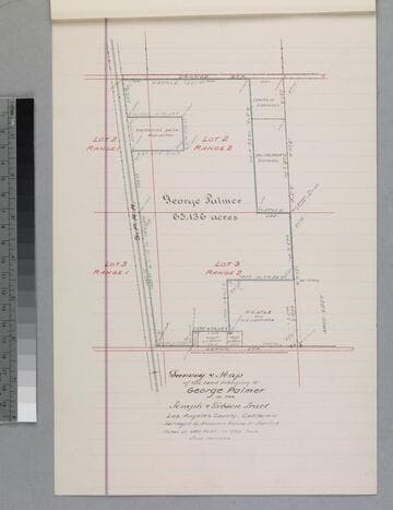
Map of the land belonging to George Palmer in the Temple & Gibson Tract
Manuscripts
P. 12 of stapled document, "George Palmer... Deed..." courses, distances, acreage, parcel owners; S.P.R.R.. Alt title supplied by cataloger.
mssSolano SR_Box_31(01).03