Opening Hours
Daily: 10 A.M.–5 P.M.
Closed on Tuesdays
1151 Oxford Road
San Marino, CA 91108
Visual Materials
Daily: 10 A.M.–5 P.M.
Closed on Tuesdays
1151 Oxford Road
San Marino, CA 91108

Visual Materials
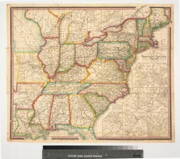
Image of a map of the Eastern United States showing roads, canals, and railroads with eleven inset maps of the environs of Albany, Saratoga, &c., the Falls of Niagara &c, Quebec, Providence, Boston, Richmond, New York, Charleston, Baltimore and Washington, Washington, D.C., and Philadelphia; with references for Washington D.C. numbered 1-10 and references for Philadelphia numbered 1-6 and a-p.
priJLC_TRAN_001189
Image not available
Rare Books
Only the eastern section of Nebraska is shown. Submap: Map showing the relationship of Nebraska to the adjoining states and territories. Prime meridian: GM, Washington. Relief: no. Graphic Scale: Miles. Projection: Polyconic. Printing Process: Lithography.
252252
Image not available
Rare Books
Bound into Guide book with smaller map of the middle states facing title page. Gift of Max Farrand. Submaps: Plan of the City of Boston; Plan of the City of New York; The Rail Road routes between Philadelphia, New York and Baltimore and Washington. Vignettes: Boston; New York; Montreal; Toronto. Prime meridian: Washington. Relief: hachures. Graphic Scale: Miles. Projection: Polyconic. Printing Process: Lithography.
224607
Image not available
Visual Materials
Kashnor notes, "Shows the remarkable amount of western settlement at the time. It locates the Green Bay Settlement in Wisconsin, and the country as far as Fort Snelling. It is the only authentic map of the Middle West of the period." Numerous tables and submaps. Cartouche: Mechanical progress. Submaps: Vicinity of Boston; Vicinity of New York; Vicinity of Philadelphia; Vicinity of Baltimore and Washington; Vicinity of Charleston; Vicinity of N. Orleans; Map of North America including all the Recent Geographical Discoveries. Tables: Statistics of the United States; Comparative heights of mountains, lengths of rivers; Index of Counties &c. in the United States; Lengths of the Principal Canals in the United States; Distances of the Erie and Champlain Canals.. Prime meridian: Washington. Relief: hachures. Graphic Scale: Miles. Projection: Pseudocylindrical. Printing Process: Lithography. Other Features: VignettesCartoucheSub-maps. Verso Text: MS notes: 599 4 sheets.
093:599 M
Image not available
Rare Books
Alt. title from cover. Submap: showing the relationship between Nebraska and adjacent states and territories. Prime meridian: GM, Washington. Relief: no. Graphic Scale: Sections. Projection: Polyconic. Printing Process: Lithography.
307070
Image not available
Rare Books
Thirteen insets (various scales): 9 insets of vicinity of principal cities (Albany, Baltimore and Washington, Rochester, Boston, etc.) -- Vicinity of the falls of Niagara -- North part of Maine -- General map of the United States with the contiguous British & Mexican possessions -- South part of Florida. Submaps: North Part of Maine; Boston; New York; Philadelphia; Rochester; Falls of Niagara; South Part of Florida; Albany; Baltimore & Washington, DC; Cincinnatti; New Orleans; Charleston; General Map of the United States with the contiguous British & Mexican Possessions. Prime meridian: GM. Relief: hachures. Graphic Scale: Miles. Projection: Polyconic. Printing Process: Lithography. Verso Text: MS note: 2066.
442669