Visual Materials
The Provinces of Lower Canada, and New Brunswick
You might also be interested in
Image not available
The Province of Upper Canada
Visual Materials
Kashnor notes, "Indicates administrative divisions, and indicates the position of Anglican and Catholic Churches." Kashnor dates as ca. 1830, watermark indicates printing as 1836 or later.See 105:690 for connecting map. MS note: C26. Prime meridian: GM. Relief: no. Graphic Scale: Miles. Projection: Pseudocylindrical. Watermark: Whatman 1836. Printing Process: Copper engraving. Verso Text: MS note: 689.
105:689 S
Image not available
A New Map of North America, agreeable to the Latest Discoveries
Visual Materials
Kashnor notes, "Shows the Pacific Coast as it was known immediately before Vancouver's discoveries. It is a good map of the North West and Alaska." See also 105:267M for an apparent later version. Ms note: 266 (on backing). Prime meridian: London. Relief: pictorial. Projection: Conic. Watermark: 1794 Whatman. Printing Process: Copper engraving. Verso Text: MS note: 266.
105:266 S
Image not available
New Map of America
Visual Materials
Kashnor notes, "printed outline, filled in and coloured by hand. Locates New Albion, St. Francisco, Santa Cruz, San Diego in California; also Juan de Fuca Strait, Skillute, Shishone in Oregon Territory." [May have been a school project.] Prime meridian: GM. Relief: hachures. Projection: Azimuthal. Watermark: Whatman Turkey Mill. Printing Process: Engraving, etching. Verso Text: MS note: 264.
105:264 S
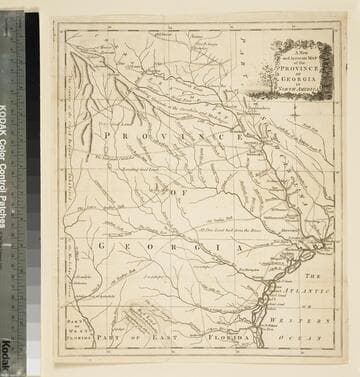
A new and accurate map of the province of Georgia in North America
Visual Materials
Kashnor notes," An old map published about 1775, shewing the roads and Indian paths." Kashnor dates c.1775. Duplicate map to 093:094S, 093:391. RLIN record notes date as [1779?] and place of publication as [London?] and as appearing in The Universal Magazine of 1779. MS note: 103 (on backing). Prime meridian: [Ferro]. Relief: pictorial. Projection: Cylindrical. Watermark: Crowned circular seal. Printing Process: Copper engraving.
105:103 S
Image not available
British America, Comprehending Canada, Labrador, New-Foundland, Nova Scotia &c:
Visual Materials
Kashnor notes, "Shows a good outline of Hudson's Bay, showing the Forts at York, Churchill and Albany. Henley is the most westerly house shown. Rupert and New Severn are destroyed." Prime meridian: London. Relief: pictorial. Projection: Pseudocylindrical. Watermark: 1799. Printing Process: Copper engraving. Verso Text: MS note: 428.
105:428 S
Image not available
Carte des Etats-Unis : Provinces Septentrionales
Visual Materials
French titled copy of English map. Kashnor dates as ca. 1792. Prime meridian: Washington. Relief: pictorial. Graphic Scale: Miles. Projection: Cylindrical. Watermark: Grapes? lettering. Printing Process: Copper engraving. Verso Text: MS note: 577.
105:577 S