Visual Materials
Hemisphere Occidental, dresée en 1720 pouir l'usage particular du Roy
You might also be interested in
Image not available
Hemisphere Occidental, dresée en 1720 pouir l'usage particular du Roy
Visual Materials
Kashnor notes, "Indicates the routes of Vaisseau, Mendana, Magellan, Gaetan, Quiros, Halley &c. This is the third issue of Delisle's map." This map bears the imprint of Phillipe Buache who reissued it in 1745. Prime meridian: Ferro. Relief: pictorial. Projection: Steriographic. Watermark: Circled device lettering. Printing Process: Copper engraving. Verso Text: MS note: 229.
105:229 M
Image not available
Mappe-Monde Dresée sur les Observations de Mrs. de l'Academie Royale des Sciences et quelques autres et sur les memoires les plus recens. A son Altesse Royale Monseigneur le Duc de Chartes
Visual Materials
Kashnor notes, "Shows the Gulf of California only reaching as high as the Bona Guia, but without the definite termination; also shows New Holland and part of New Zealand, with the tracks of Mendana, Dampier, Olivier, Tasman, Pelsart, Magellan and le Maire." Shirley shows this as first edition, 1700, note slant of South America's tip to the west. See also 093:181, 105:244 and 105:245 for later editions. Cartouche - figures representing four continents. Prime meridian: Ferro. Relief: pictorial. Projection: Dual Hemisphere. Watermark: Chained Maltese cross. Printing Process: Copper engraving. Other Features: Cartouche. References: Shirley 603. Verso Text: MS notes: 180 3.
093:180 M
Image not available
Mappe-Monde Dresée sur les Observations de Mrs. de l'Academie Royale des Sciences et quelques autres et sur les memoires les plus recens. A son Altesse Royale Monseigneur le Duc de Chartes
Visual Materials
Kashnor notes, "Shows the Gulf of California only reaching as high as the Bona Guia, but without the definite termination; also shows New Holland and part of New Zealand, with the tracks of Mendana, Dampier, Olivier, Tasman, Pelsart, Magellan and le Maire." This appears to be a later state of the 1700 map, see 093:180. The slant of South America has been corrected eastward, some new names appear on the west coast of Africa, and a new mountain range in Siberia. Image is lighter than 1700 original. See also 093:181, 105:244 and 105:245 for later editions. Cartouche - figures representing four continents. Prime meridian: Ferro. Relief: pictorial. Projection: Dual Hemisphere. Watermark: Chained Maltese cross. Printing Process: Copper engraving. Other Features: Cartouche. References: Shirley 603. Verso Text: MS notes: 245.
105:245 M
Image not available
Mappe-Monde Dresée a l'usage du Roy. Par Guillaume Delisle Premier Geographe de S. M
Visual Materials
Kashnor notes, "The western coast of America goes no further north than Cape Blanc, but California is a peninsula, although the gulf is very incorrectly represented. New Guinea appears as part of Australia. The route of Tasmon's voyage in 1642 is shown. This is one of Delisle's earlier maps, which show California as a peninsula." This is a copy of L'Isle's 1700 map (093:180) with added border art, redone cartouche, the tip of South America corrected, the Solomon Islands moved. Compare with 093:181M which Kashnor dated as [1720]. This map has a more correctly drawn California peninsula. Frisland is no longer shown below Greenland on this map. RLIN record gives appeared in information. Cartouche - figures representing four continents. Royal crest center. . Prime meridian: Ferro. Relief: pictorial. Projection: Dual Hemisphere. Printing Process: Copper engraving. Other Features: CartoucheSub-maps. References: Shirley 603 (mentioned). Verso Text: MS notes: 181.
105:244 M
Image not available
Carte D'Amerique Dresée pour l'Usage du Roy Par Guillaume Delisle premier Geographe de Sa Majesté de l'Acadaemie Royale des Sciences
Visual Materials
Kashnor notes, "Terminates the west coast of America at "Entrée decouvert par Martin d'Aquilar," and locates San Francisco and Monterey. Shows California as a peninsula and as a separate province." See 105:214 for an earlier version of this map. This map a reprint of the original 1722 map, done by Phillipe Buache in 1745. Prime meridian: Ferro. Relief: pictorial. Projection: Pseudocylindrical. Watermark: Device with petalled circle lettering. Printing Process: Copper engraving. Other Features: Cartouche. Verso Text: MS note: 215 76.
105:215 M
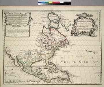
L'Amerique Septentrionale, Dresée sur les Observations de. Mrs. de l'Academie Royale des Sciences. & quelques autres, & sur les Memoires les plus recens
Visual Materials
Kashnor notes, " Shows the Gulf of California reaching only as far north as the Bona Guia River, the north-west coast has its limit at Cap Mendocin. It locates the Sierra Nevada Mountains, Port de Drak and New Albion, and also the tracks of Cortez, Drake, Olivier, Mendana and Gaetana. One of the best maps to show the geographical knowledge of California at the beginning of the 18th century." George Carhart of Osher Map Library confirms this map to be state 2, published in [1701]. See 093:160M for a later version of this map. Cartouche and figured scale bar. Includes Avertissement.. Prime meridian: Ferro. Relief: pictorial. Graphic Scale: Leagues, various. Projection: Pseudocylindrical. Watermark: Chained Maltese cross. Printing Process: Copper engraving. Other Features: CartoucheFigures . Verso Text: MS notes: 72 (on folded left edge); 159 Mus. Bk St. 93/159 25.
093:159 M