Manuscripts
City of Los Angeles, 1890

You might also be interested in

Plat of Lot in the city of Los Angeles
Manuscripts
N.E. corner of Buena Vista and College Sts.. Surveyed for Joseph Mullaly, Esq.. Featuring proposed building site 53 x 90 ft. on College St. @ Buena Vista. Courses, distances
mssSolano SR_Map_0662.01
![Map of the City of Los Angeles: [showing weight of rails laid]](/_next/image?url=https%3A%2F%2Frail.huntington.org%2FIIIF3%2FImage%2F22APN4635XVA%2Ffull%2F%5E360%2C%2F0%2Fdefault.jpg&w=750&q=75)
Map of the City of Los Angeles: [showing weight of rails laid]
Rare Books
Shows streets and prospective electric streetcar lines in red and black. Probably dates before 1903 as the rail lines are not named. Legend gives weights of rails laid. Covers the city of Los Angeles with the Los Angeles Country Club to the West, Slauson Ave. to the South, the Evergreen Cemetery in Boyle Heights to the East, and Elysian Park to the North. "H.E.H." are the initials of Henry E. Huntington, who owned the Pacific Electric Railway Company. Scale statement on map reads "1320 feet to one inch." Coordinates not present on map, approximated from Google maps. Relief given in hachures. Provenance unknown, in library as of 2017. Appears to have come from the office of one of Henry E. Huntington's railway companies.
646649
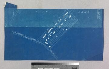
Los Angeles : Solano Tract No. 2
Manuscripts
Segment of preceding map also depicting Solano SE Tract with structures; showing Catholic Cemetery to the south. Title supplied by cataloger.
mssSolano SR_Map_0743.03
![Map of the City of Los Angeles: franchises advertised -- red; franchises pending -- green [cartographic material]](/_next/image?url=https%3A%2F%2Frail.huntington.org%2FIIIF3%2FImage%2F22APN46JZCS0%2Ffull%2F%5E360%2C%2F0%2Fdefault.jpg&w=750&q=75)
Map of the City of Los Angeles: franchises advertised -- red; franchises pending -- green [cartographic material]
Rare Books
Shows streets and prospective electric streetcar lines. The red lines show franchise lines advertised for sale, and have various sale dates between January to May 1903 annotated in pencil. Pending sales are indicated in green. Map was again issued with the subsequent railway lines in place under the title "Map of the City of Los Angeles showing railway system" Covers the city of Los Angeles with the Los Angeles Country Club to the West, Slauson Ave. to the South, the Evergreen Cemetery in Boyle Heights to the East, and Elysian Park to the North. Scale statement on map reads "1320 feet to one inch." Coordinates not present on map, approximated from Google maps. Relief given in hachures. Provenance unknown, in library as of 2017. Appears to have come from the office of one of Henry E. Huntington's railway companies.
646646

Map of the City of Los Angeles showing railway system. Sept. 3rd 1904, Sept. 17th 1904
Rare Books
Shows streets and electric streetcar lines. The streetcar lines for Los Angeles Railway Company, Pacific Electric Railway Company, Los Angeles Inter-Urban Railway and Los Angles Pacific Rail Road are depicted in different colors. Covers the city of Los Angeles with the Los Angeles Country Club to the West, Slauson Ave. to the South, the Evergreen Cemetery in Boyle Heights to the East, and Elysian Park to the North. Scale statement on map reads "1320 feet to one inch." Coordinates not present on map, approximated from Google maps. Relief given in hachures. Provenance unknown, in library as of 2017. Appears to have come from the office of one of Henry E. Huntington's railway companies.
646648

Map of the City of Los Angeles showing railway system. May 15, 1903, September 1, 1903
Rare Books
Shows streets and electric streetcar lines. The streetcar lines for Los Angeles Railway Company, Pacific Electric Railway Company, Pacific Electric Railway Company Franchises, Los Angeles Traction Co., Los Angles Pacific Rail Road and Kays Franchise are depicted in different colors. Covers the city of Los Angeles with the Los Angeles Country Club to the West, Slauson Ave. to the South, the Evergreen Cemetery in Boyle Heights to the East, and Elysian Park to the North. Scale statement on map reads "1320 feet to one inch." Coordinates not present on map, approximated from Google maps. Relief given in hachures. Stamped on verso: Olin G. McWain Blue Printing and Map Mounting. Byrne Bldg., Los Angeles, Cal. Provenance unknown, in library as of 2017. Appears to have come from the office of one of Henry E. Huntington's railway companies.
646647