Visual Materials
California, Utah, Lr. California and New Mexico
You might also be interested in
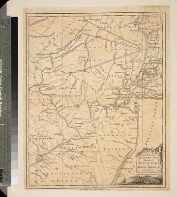
New and Accurate Map of the Present Seat of War in North America, Comprehending New Jersey, Philadelphia, Pensylvania (sic), New-York &c
Visual Materials
Kashnor dates as c.1770. Probably later because of reference to Revolutionary War. Some notes regarding boundary dispute between New York and New Jersey. Small vined cartouche with sailing ship. MS note: 101 (on backing). Prime meridian: London. Relief: pictorial. Graphic Scale: Miles, statute. Projection: Cylindrical. Watermark: Crowned seal. Printing Process: Copper engraving. Other Features: Cartouche. Verso Text: MS note: 410 (map) 101 (on backing).
093:101 S

Map of the Country round Philadelphia including part of New Jersey New York Staten Island & Long Island
Visual Materials
Kashnor notes, "a scarce war map." MS note: 121 (on backing). Prime meridian: London. Relief: pictorial. Graphic Scale: Miles, British Statute. Projection: Cylindrical. Watermark: Crowned seal. Printing Process: Copper engraving. Verso Text: MS note: 121 (on backing).
093:121 S
Image not available
British Columbia (New Caledonia); Vancouver Island
Visual Materials
Two maps on one sheet. Kashnor dates as ca. 1850. Seal of The Dispatch Atlas. Prime meridian: GM. Relief: hachures. Graphic Scale: Miles. Projection: Mercator. Printing Process: Lithography. Other Features: Art Work. Verso Text: MS note: 193.
105:193 S
Image not available
California, Utah, Lr. California and New Mexico
Rare Books
Nevada and Arizona are yet to come. MS notes: 100 436 57466. Prime meridian: Gm. Relief: hachures. Graphic Scale: Miles. Projection: Conic. Printing Process: Lithography. Verso Text: MS notes: California New Mexico ro 100.
57465

New and Accurate Map of North Carolina in North America
Visual Materials
Kashnor notes,"A scarce map issued during the early days of the American Revolution." Kashnor dates as [1776]. MS note: 376 (on map and backing). Transfer text upper left corner.. Prime meridian: London. Relief: pictorial. Graphic Scale: Miles. Projection: Plane. Watermark: Two seals.. Printing Process: Copper engraving. Other Features: Cartouche. Verso Text: MS note: 11. 376(on backing)..
093:376 S

New and Accuarte Map of the Isles of Guadaloupe, Marie-Galante &c. from the Best Authorities
Visual Materials
Kashnor dates as ca. 1759. MS note: 774 (on backing). Prime meridian: London. Relief: pictorial. Graphic Scale: Miles. Projection: Cylindrical. Printing Process: Copper engraving. Verso Text: MS note: 774 (on backing).
093:774 S