Manuscripts
1876 July 20 Block 35 & 35 1/2 Ord Survey

You might also be interested in

Map of Block 35 1/2, Being an extension of Ord Survey
Manuscripts
Date of original survey: 1876 July 20, recorded on the 21st. Short St. to Amat Tract, from Rosas to Teed and Yale St., plus Castelar St., with names of lot owners. Affixed: 1883 news clipping of Ordinance No. 107 (Mayor Cameron E. Thom 1882-1884). Alternate title supplied by cataloger.
mssSolano SR_Map_0466.01
Image not available
Kelleher, M
Manuscripts
Map of Block 35 1/2, Being an extension of Ord Survey [Short St. to Amat Tract, from Rosas to Teed and Yale St., plus Castelar St., with names of lot owners. Affixed: news clip of Ordinance No. 107] [2 pieces, also including: variant of preceding map]
mssSolano
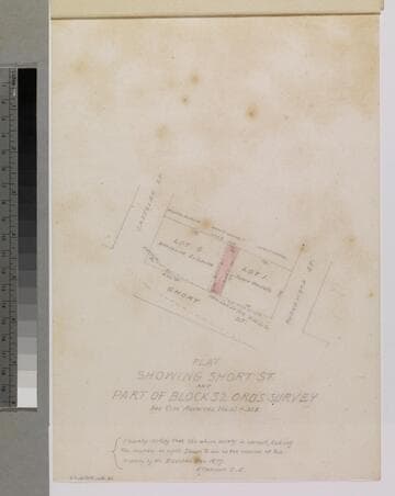
Plat Showing Short St. and Part of Block 32 Ord's Survey
Manuscripts
P. 4 of stapled document, "Louis Sentous & Bros..." [see City Archives Vol. 13 p. 338]; featuring lots G & I along Short St. between Castelar & Buena Vista streets; showing parcel owners: Coronel, Mascarel, Buelna, courses, distances. Alt title supplied by cataloger.
mssSolano SR_Box_33(16).02

Block & Fort Hill Tract
Manuscripts
Castelar to Buena Vista St., Bellevue Ave. (Short St.) to Sand St., showing structures, lot owners, with notes; courses, distances, survey history. Paper watermark: Southworth’s 1882 Linen Bank. Alt title supplied by cataloger.
mssSolano SR_Map_0737

Map of Lot 1 Block 7 Ord's Survey
Manuscripts
Fourth St., Fort to Spring St., showing structures, frontages, lot owners; colored ink, hachures, courses, distances. Paper watermark: Southworth’s 1882 Linen Bank. . Alt title supplied by cataloger.
mssSolano SR_Map_0709.01

Block 16 of Ord's Survey
Manuscripts
Main to Spring St. from Sixth to Seventh St., showing structures, frontages, lot owners including Geo. Hansen; pencil calculations. Affixed: description of 15 ft. alley in two 6 x 8 3/4 in. sheets. Extensive manuscript notations and additions.. Alt title supplied by cataloger.
mssSolano SR_Map_0658.01